
Amid growing concerns and recent warnings over the potential threat of Glacial Lake Outburst Floods (GLOFs) in Arunachal Pradesh’s Tawang district, a satellite-based assessment has revealed changing behaviour of five potentially dangerous glacial lakes in the Mago Chu Basin.
Using high-resolution multi-sensor imagery, Suhora Technologies, a geospatial intelligence firm, conducted a comparative analysis of five potentially dangerous glacial lakes identified by the National Disaster Management Authority (NDMA) as being in the high-risk category.
The assessment examined changes in their spatial extent and current condition through satellite observations spanning 2016 to June 2026. The analysis provides an updated view of lake expansion patterns and evolving conditions across the basin, offering valuable geospatial insights to support disaster preparedness and long-term climate resilience planning.
In a comparative assessment of five potentially dangerous glacial lakes the data shows that four out of five lakes have expanded, reflecting a general trend of glacial retreat and meltwater storage. Although lake expansion does not directly indicate a flood event, it highlights the importance of regular monitoring and further assessment to better understand future risks.
In the analysis, a lake showed an expansion trend growing from 20.19 ha in 2016 to 21.75 ha on June 15 indicating water accumulation. Despite moderate growth, its classification as a Very High-Risk Lake under the NDMA inventory emphasises the need for continued monitoring.
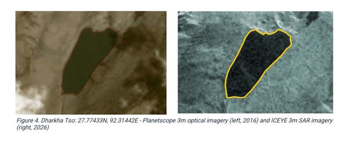
Likewise, Dharkha Tso lake demonstrates moderate but consistent expansion from 12.40 ha in 2016 to 12.69 ha in 2026, reaching 12.73 ha in the most recent observation. It’s classified as High Risk by NDMA.
Commenting on the findings, Amit Kumar, Co-founder & COO, Suhora Technologies, said that the study highlights the value of satellite-based geospatial analysis in monitoring remote Himalayan environments where field access is often difficult and weather dependent.
“By comparing satellite imagery across multiple years, it is possible to track changes in glacial lake extent, monitor landscape evolution and provide an updated understanding of conditions in these high-altitude regions. With the monsoon season approaching, continuous observation of glacial lakes becomes increasingly important and satellite-based observations can complement field investigations by providing timely information on lake expansion, glacier retreat and broader landscape changes across remote high-altitude environments,” he said.
