
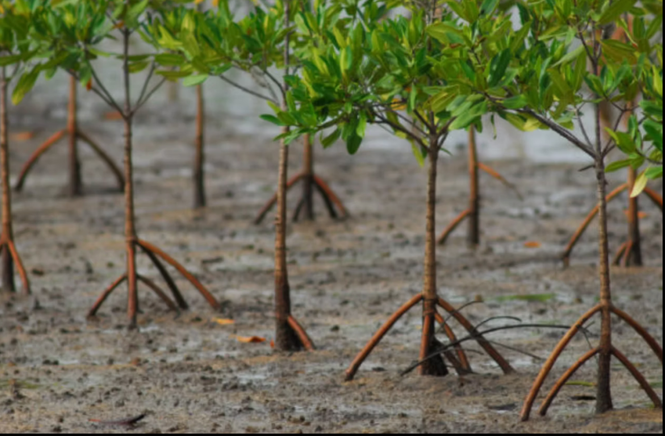
THE world’s coastal landscapes are at a critical turning point. As highlighted in The State of the World’s Mangroves 2026 report, decades of mangrove decline are showing signs of reversal in some regions. While global mangrove cover is stabilizing and, in some areas, expanding, old-growth forests remain under threat from coastal development, climate change and aquaculture expansion. Newly established forests cannot immediately replace the ecological functions of mature mangroves.
Mangroves are essential to coastal resilience. They store substantial amounts of carbon, particularly in their soils, provide nurseries for marine life and serve as natural barriers against storm surges. Protecting these ecosystems requires more than planting seedlings. It demands a better understanding of suitable growing conditions and whether restoration efforts produce lasting results.
“Reversing the decline of these habitats isn’t just a science; it’s an art,” As marine biologist Octavio Aburto observed. Digital tools can help translate ecological knowledge into more effective conservation measures.
Technology as a tool for conservation
As an archipelago vulnerable to sea-level rise and destructive typhoons, the Philippines could benefit from technologies that make mangrove conservation more precise. Satellite imagery, geographic information systems and artificial intelligence (AI) can help researchers map mangrove habitats, track changes in forest cover and identify potential restoration sites.
Mangrove planting projects have struggled with survival rates as low as 10 percent to 20 percent. Research on local rehabilitation efforts has identified poor site selection as a major cause. Planting in unsuitable tidal zones, using species that do not match local conditions or placing seedlings on seagrass beds can undermine restoration from the outset.
Remote sensing and machine learning offer ways to address these problems. Support vector machine (SVM) algorithms, for example, have proved effective in distinguishing mangroves from other land cover in satellite images. A 2023 review of Philippine mangrove remote-sensing studies documented their usefulness in mapping mangrove distribution. Such methods can guide field assessments and reveal changes in forest cover, although mapping alone cannot establish ecosystem health or restoration success.
Unmanned aerial vehicles, or drones, can survey inaccessible coastal areas and capture high-resolution images. Combined with satellite data and field observations, these images provide a closer look at vegetation and habitat conditions, helping researchers identify areas that need further assessment.
Environmental sensors offer another source of information. Internet of Things (IoT) devices can measure water temperature, salinity and water levels, helping scientists understand how mangroves respond to environmental stress. Carbon flux towers measure exchanges of carbon dioxide between ecosystems and the atmosphere, contributing to research on mangroves’ role in the carbon cycle. Reliable results, however, require sustained monitoring and careful interpretation.
Blockchain-based platforms could improve transparency in conservation financing by creating tamper-evident records of transactions, project reports and payments to local participants. Such records can help track the use of funds, but they cannot independently establish whether mangroves have survived or ecosystems have recovered. Those claims require field measurements and independent verification.
Empowering local communities
Technology will have limited value if it excludes the people who live alongside mangrove forests. Coastal communities possess knowledge of local waterways, vegetation and changing environmental conditions that can complement scientific monitoring.
Mobile applications can help residents document changes in mangrove cover, report illegal encroachment and contribute observations to conservation databases. These citizen-science initiatives can supplement satellite imagery and professional field surveys, providing information that remote monitoring might miss.
Some conservation models also explore financial incentives for communities that achieve measurable environmental results. These arrangements require clear standards, transparent payment systems and independent verification. When properly designed, digital platforms can help link conservation funding to documented outcomes and make the use of resources easier to track.
The approach reflects a principle emphasized by scientist Catherine Lovelock in her research on mangroves as nature-based solutions: conservation measures must be grounded in an understanding of mangrove ecology. Digital tools can collect and analyze information, but ecological expertise remains essential in deciding how that information should guide restoration.
A future built on better data
The findings in The State of the World’s Mangroves 2026 offer reason for cautious optimism, but improvements in global mangrove cover should not obscure continuing losses. Successful restoration means protecting existing forests, selecting suitable sites and species, and monitoring whether ecosystems recover rather than simply counting seedlings planted.
Satellite imagery, machine learning, drones and environmental sensors can improve how conservationists assess habitats and monitor changes. Community reporting can add local observations, while blockchain may help document the flow of conservation funds. Together, these tools could make restoration efforts more accountable, provided that environmental outcomes are independently assessed.
Technology alone cannot address the underlying causes of mangrove loss. Coastal development, aquaculture expansion, weak enforcement and competing demands for land require effective policies and sustained community participation. Digital tools can help governments, researchers and local communities determine where intervention is needed and assess whether it works, but they cannot replace those responsibilities.
The future of Philippine mangroves will depend on combining reliable data with ecological science and local knowledge. The real measure of technological progress will be whether these forests survive, recover and continue protecting the communities and coastlines that depend on them.