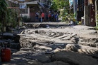
- Aerial footage shows the devastation caused by a powerful magnitude 7.8 earthquake that struck Mindanao in the Philippines on Monday, resulting in at least 32 fatalities, over 200 injuries, and nearly two dozen people missing.
- The earthquake generated tsunami waves exceeding one meter (3 feet), impacting nearby coastlines, with a peak of 1.4 meters (4.5 feet) recorded in Kiamba town, Sarangani.
- General Santos City was severely affected, experiencing building collapses, significant damage to critical infrastructure, and prompting the evacuation of 10,000 residents.
- Eyewitnesses described widespread panic as the ground shook, with videos showing a school building collapse and a shopping center reduced to rubble.
- The Philippines, situated on the Pacific "Ring of Fire," is prone to such seismic events, and President Ferdinand Marcos Jr. pledged federal government support for Mindanao.
IN FULL