
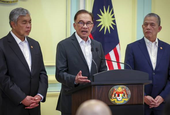
Malaysia’s 10th Prime Minister, YAB Dato Seri Anwar Ibrahim had announced the responsibilities of newly elected Deputy Prime Ministers Datuk Seri Dr Ahmad Zahid Hamidi and Datuk Seri Fadillah Yusof on 5th December 2022. (Astro Awani)
Recognizing the urgent need for the nation to prepare effectively for the flood hazard forecasted by MetMalaysia that will impact Malaysia till March 2023, the Prime Minister had entrusted Deputy Prime Minister Datuk Seri Dr Ahmad Zahid Hamidi to oversee the disaster management in the country and serve as Chair of the Disaster Management Committee. (See Fig 1)
An urgent and immediate task outlined by the PM is for Malaysia’s Disaster Management Committee steered by DPM Datuk Seri Dr Ahmad Zahid Hamidi to come out with immediate measures to monitor the situation and make preparations (for floods). (Astro Awani)
I would like to offer the following recommendations for Malaysia.
Recommendations for Malaysia
1. Restructure Malaysia’s Disaster Management Committee to Disaster Risk Reduction (DRR) Committee
Madam Mami Mizutori, Special Representative of the Secretary-General for Disaster Risk Reduction United Nations Office for Disaster Risk Reduction (UNDRR) had articulated that “Over the last twenty years thinking about how to reduce disaster losses has greatly expanded beyond a simple focus on disaster management to consideration of all the other elements that contribute to increasing the risk of loss of life, injury, damage to critical infrastructure and economic losses when disaster strikes.”
Thus in tandem with global developments where reducing disaster losses has expanded beyond a simple focus on disaster management to disaster risk reduction (DRR), Malaysia should restructure its present Disaster Management Committee to Disaster Risk Reduction (DRR) Committee.
2. Introduce Scenario Planning in planning for the flood hazard
It is imperative for Malaysia to develop strategies for effective disaster risk reduction.
In addition to responding to flood hazards, it is critical for the Disaster Risk Reduction Committee to develop 3 possible scenarios:
A. One; a most drastic and unexpected impact by the flood, including loss of critical infrastructures such as airports/transportation services, and communication services amongst others, and then outline possible preparations and responses.
B. A not so drastic but slightly unexpected scenario, with the floods impacting slightly differently from previous incidents and then outline preparation necessary to address this.
C. Ordinary flood impacts such as those experienced before and plan accordingly the preparations required with improvements greatly needed.
3. Embrace and invest in technologies to effectively support Disaster Risk Reduction
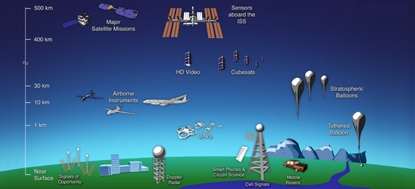
During the recent 3rd Global Drones Conference 2022 held in conjunction with the iNNOVATE Tech Show at MATRADE Exhibition Centre, discussions were held to share views and insights on Fusion of Earth Observation (EO), Artificial Intelligence (AI) and Drones for Better Global Disaster Management. (See Fig 2)

I had spotlighted on some of the technologies key for disaster management including EO and Drones. (See Fig 3 and Fig 4)

Remote Sensing Technologies for Mitigating Disasters- Spotlighting on EO and Drones
Situational awareness on the ground is crucial for effective disaster management and several remote sensing technologies including Earth Observation (EO) satellites and drones are amongst key technologies providing important information to key decision makers on the ground.
The availability of satellites allows monitoring of hazards including floods on a wider scale whilst drones are beneficial for monitoring relatively smaller areas. (See Fig 4)
4. Malaysia to create Flood Hazard Maps accessible to the Public
It is recognized that for a successful DM programme, risks and vulnerability must first be identified via data collection and mapping, only then mitigation and preparedness plans are developed from these critical initial information.
Globally international agencies and bodies, supported by work undertaken by scientists, researchers and other professionals have recognized that the most effective way of reducing hazard risk to lives, livehood, properties, infrastructure and economy is through the production of hazard maps and hazard risk maps.
In the case of flood, flood hazard assessment and mapping illustrated by flood hazard maps is used to identify areas at risk of flooding to help enhance disaster mitigation and preparedness.
According to the OECD’s Provision of Hazard Maps- Selected Global Good Practices and an inventory of online Hazard Information in South East Asia by Owen Gough, August 2008, as draft for circulation at the 2 nd Conference of the International Network in Bangkok, Thailand, 24-25 September 2009, an ideal hazard map should include the following: height of inundation, velocity (speed and direction of water) likelihood of debris, risk of secondary hazard including landslide, mudslide.
Hazards need to be assessed in terms of their probability of occurrence and severity (intensity). For example, floods are often defined according to their likelihood of occurring in any given year.
The most commonly used definition in planning is the '1 in 100 year flood' or 1:100 year flood. This refers to a flood level or peak that has a one in a hundred, or 1%, chance of being equaled or exceeded in any year. Others include 1:20, 1:30,1:50, 1:200 and 1:300 year flood which corresponds to a 5%, 3%, 2%, 0.5% and 0.3% risk of flooding in any one year.
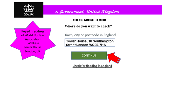
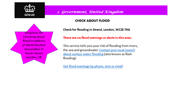
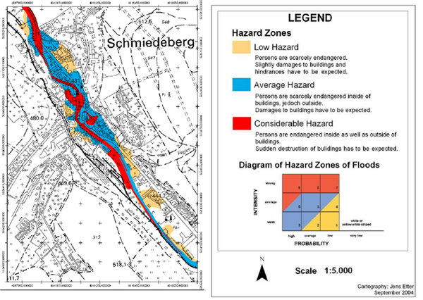
I had shared specific examples of international best practices by the United Kingdom (See Fig 5i and Fig 5ii), Switzerland (See Fig 5iii) and Japan (See Fig 5iv) using Earth Observation satellites and other technologies to develop critical Flood Hazard Maps which were accessible to the public via website with public keying in the address, location or postcode. In Japan’s case evacuation routes and evacuation centres were also identified in the hazard map to guide public at risk to take suitable routes to reach evacuation centres safely
Some of the above also include advisories to public on What to Do and What Not to Do BEFORE, DURING and AFTER the Flood hazard.
5. i) Environmental Agency - United Kingdom
In the United Kingdom, its Environmental Agency offers opportunities for its citizens and those living, working and holidaying on the UK to check flood risk in their area by keying their address including postcode. A response will appear to indicate the situation of the location (See Fig 5i and Fig 5ii)
5. ii) National Emergency Operations Centre (NEOC)- Switzerland
Central Switzerland was impacted by severe flooding in 2005 and its NEOC had invoked the International Charter on Space and major Disasters requesting for support for remote sensing data for disaster management. They also speeded up the process to complete hazard maps for the country which defines areas of flooding, rockslides and the Federal Office for Water and Geology promised to upgrade its Early Warning System. The Swiss Federal Office for the Environment (FOEN) develops the Hazard Maps
5. iii) MLIT and the Prefecture Government, Japan
In Japan, the Ministry of Land, Infrastructure, Transport and Tourism (MLIT) and the Prefecture Government ( which are responsible for managing rivers) identify Flood Hazard areas along rivers designated for flood forecasting and river water reporting activities
Municipalities that contain areas where flooding from rivers is expected to occur are creating Flood Hazard Maps that includes information such as flood hazard areas, probable water depth, evacuation sites, flood forecast communications methods ( see Fig 5d)
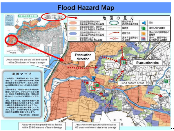
In striving to distribute these hazard maps to as many as possible, the Municipalities undertakes the following; displaying in Government Offices, Civic Halls and Hospitals, distributing to individual homes, publishing in newsletters and websites, using them as teaching materials in elementary and junior high schools, and holding community meeting about them.
5. iv) Malaysia
On 10 March 2022, nearly 3 months after Malaysia’s worse flood in December 2021, news reported that then Minister of Environment and Water (KASA) YB Tuan Ibrahim had informed that flood disaster risk assessment will be carried out through flood hazard and flood risk maps under the DID covering 36 major river basins nationwide and this is expected to be completed by 2024, with flood hazard maps for 6 river basins and 1 flood risk map in Sg Bernam in Klang valley already developed.
News on 2nd October 2022 reported that then Minister of Science, Technology and Innovation Ministry (MOSTI) Datuk Seri Dr Adham Baba had announced that MOSTI will use remote sensing technology developed by the Malaysian Space Agency (MYSA), including satellites for data observation through radar and optical methods in locations with frequent floods based on 10 years of experience to identify flood-prone areas so as to make early preparations.
The then Minister explained that with rain measurements and the cooperation of the Malaysian Meteorological Department (Met Malaysia), MOSTI can warn the government of flood hotspots when the monsoon sets in so that preparations can be made in advance.
The remote sensing technology had been presented to then Prime Minister Datuk Seri Ismail Sabri Yaakob.
Malaysia from OECD’d point of view (in 2009)
The OECD’s Provision of Hazard Maps, September 2009 had highlighted that Malaysia’s Department of Irrigation and Drainage (DID) is responsible for flood planning and that the responsibility is divided into River Basin Management Unit (RBMU) with each Unit having a Flood Hazard Map for their area based on Maximum Historical Flood data and not on any probabilistic method. Additionally, the OCED drew attention to the fact that these hazard maps are not available on-line to the public. The OECD outlined that Malaysia’s hazard map seem of a high standard but dovetailed that these hazard maps should be made available on-line to the public.
Recommendation No. 6
It is encouraging to note that KASA via the Department of Irrigation and Drainage (DID) is producing flood hazard and risk maps and that MOSTI is introducing remote sensing technologies to identify flood prone locations based on knowledge of 10 years of experience of flood and that these would be provided to all ministries and their agencies
6. i) In addition of an indication of the extent of expected risk areas illustrated in the hazard map, the Malaysian Government should consider combining with disaster management information such as evacuation sites, evacuation routes such as in the case of Japan as well as guide on what to do and not to do before, during and after a hazard as outline by selected countries overseas.
6. ii) With reference to the OECD’s remarks regarding Malaysia’s efforts in developing Flood Hazard Map which is based on maximum historical flood data and not probabilistic methods, and that it was not available online to the public, it is strongly recommended that Malaysia MUST offer these flood hazard maps to public, businesses and others living, working and holidaying in Malaysia to access these important information including whether their location is at risk, the evacuation routes and nearest shelters to guide them to make informed decision for their safety and survival.
6. iii) For public with no access to computers or Wifi, Government could emulate Japan’s best practice of disseminating these hazard maps by distributing them at Government offices, Civic halls and Hospitals, distributing to individual homes, publishing in newsletters and websites, using them as teaching materials in primary, secondary schools as well as at Institutions of higher learning, and holding a community meeting about them and share with media for publication to reach readers nationwide
In summary hazard maps are particularly important to enable public to find out whether their homes, offices, buildings, areas, location they are staying, travelling to or passing through are at risk of flooding. (See Fig 5v)
7. Establish Collaboration with International Partners in Disaster Risk Reduction
In view that disaster impacts are extensive and destructive and that not one nation is able to reduce risks and manage entirely on its own, it is imperative for Malaysia via the Disaster Management Committee (Disaster Risk Reduction Committee) to establish collaboration with international partners including the US, UK, Europe, Japan, China and ASEAN, amongst others to enhance the nation’s skills, competency and experience in disaster risk management.
A case in point, following from the Government of Japan’s kind support to assist Malaysia in Disaster Risk Management in the wake of the nation’s worse flood in December 2021, as shared by Japan’s Ambassador to Malaysia, Takahashi Katsuhiko on 7 January 2022, who highlighted that this would be an important pillar for cooperation, the Government of Malaysia should welcome this important offer and establish collaboration in this critical area in which Japan has extensive experience and expertise, in an effort to reduce the impact of disasters for the nation and rakyat as well as others living, studying, doing business and holidaying in Malaysia.

Part 2: Will focus on Drone tech for Mitigating and Preparing for Disaster Management
Sheriffah Dato Syed is a content creator under the Newswav Creator programme, where you get to express yourself, be a citizen journalist, and at the same time monetize your content & reach millions of users on Newswav.
Log in to creator.newswav.com and become a Newswav Creator now!
Newswav is solely an aggregation platform and hosts the content. The views expressed and content above including media (pictures, videos, etc) were provided by the author. If you have any questions about the content, copyright or other issues of the work, please contact Newswav.
