The magnitude 7.7 earthquake that struck off Indonesia’s Flores Island early Saturday was generated by an unusual fault system that has produced destructive earthquakes and tsunamis in the past, according to a rapid analysis by earthquake researchers Kyle Bradley and Judith Hubbard.
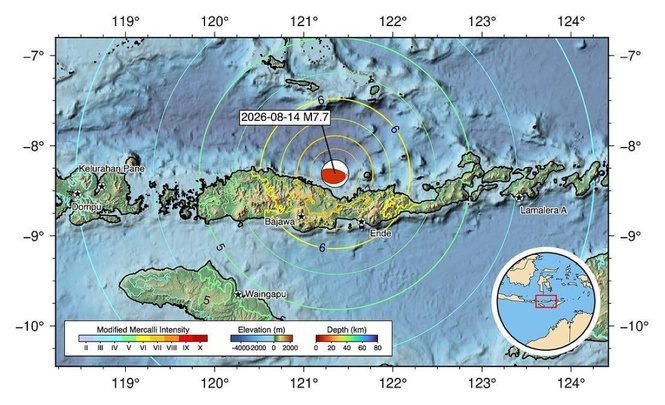
The earthquake struck at 5:58 a.m. local time at a depth of about 10 kilometers, according to the U.S. Geological Survey. Its epicenter was about 68 kilometers north-northwest of Ende in East Nusa Tenggara province.
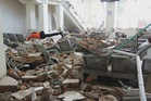
The quake killed at least five people and caused building collapses and other damage, The Associated Press reported. A tsunami warning was issued after the shallow undersea earthquake but was later lifted after Indonesian authorities determined that there was no continuing threat to coastal communities.
Bradley and Hubbard, writing for Earthquake Insights, said the earthquake appears to have occurred on the Flores Thrust, a major fault system running along the northern side of the Lesser Sunda Islands from eastern Java through Bali, Lombok, Sumbawa and Flores.
Their analysis is preliminary and based on early earthquake locations, a USGS focal mechanism and previously published geological studies. The researchers said the interpretation could change as more seismic and geological data become available.
What makes the Flores Thrust unusual is that it is a backthrust.
To the south, the Australian plate is being pushed northward beneath the Sunda plate. That process is responsible for the major subduction zone and volcanic arc running through Indonesia. The Flores Thrust represents a separate fault system in which the crust is being pushed in the opposite direction, toward and over the Sunda plate.
Bradley and Hubbard said backthrusts of this type are relatively uncommon and remain poorly understood from both geological and earthquake-hazard perspectives.
The early earthquake pattern provides clues about how Saturday's rupture occurred. The researchers identified 13 early aftershocks of magnitude 4.5 or greater spread across roughly 160 kilometers, a distance consistent with the expected rupture length of a magnitude 7.7 earthquake.
The distribution suggests that the rupture began toward the eastern end of the zone and propagated westward.
The researchers also found that the earthquake occurred on the steeper portion of the Flores Thrust, rather than on the shallowest section of the fault farther offshore. The USGS focal mechanism indicates a fault dip of about 29 degrees.
That geometry helps explain why the earthquake occurred relatively close to Flores.
A 1986 marine geophysical survey found extensive folds and faults in the Flores Basin. Bradley and Hubbard said the shallowest part of the Flores Thrust is extremely gently sloping and may move gradually rather than producing large earthquakes. The part capable of generating major earthquakes appears to be a steeper ramp closer to the island.
That distinction matters for hazard assessment because a large rupture on a fault close to the coast can produce strong shaking before seismic energy has dissipated with distance.
The earthquake also demonstrated the tsunami hazard associated with the fault.
Because the rupture was large, shallow and involved thrust motion, Indonesian authorities issued a tsunami warning and urged coastal residents to move to higher ground. Small tsunami waves were subsequently recorded, with Reuters reporting waves of less than 1 meter in several locations before the warning was lifted about three hours after the earthquake.
The danger is particularly significant because Flores has experienced a much larger tsunami disaster from the same general fault system.
On Dec. 12, 1992, a magnitude 7.7 earthquake struck beneath northern Flores. Bradley and Hubbard said the resulting tsunami was probably amplified by an underwater landslide and produced runups exceeding 20 meters in some locations. More than 2,000 people were killed.
The 1992 earthquake was close to Saturday's event, making the historical record particularly relevant to the current hazard.
The Flores Thrust has also produced destructive earthquakes elsewhere. In 2018, two magnitude 6.9 earthquakes struck beneath Lombok, west of Flores, causing widespread damage but no significant tsunami.
The researchers said the latest earthquake could provide new information about the structure of the Flores Thrust. Large earthquakes deform the land around the rupture, potentially raising or lowering sections of the coastline.
That deformation can leave geological evidence, including changes to coral reefs and coastal terraces. Such evidence can help scientists determine how the fault has moved during earthquakes that occurred before modern instruments existed.
A 2024 study by Harisma Andikagumi and Bradley modeled the Flores Thrust using seismic data and coastal geological features. It identified areas of long-term uplift and subsidence along the fault, providing additional clues about how the fault behaves.
The USGS has also produced a preliminary model of the 2026 rupture. It indicates an east-west-oriented rupture dipping southward, with maximum slip estimated at about 2.6 meters.
Bradley and Hubbard cautioned that the early model remains subject to revision. The USGS estimates of shaking and potential impacts depend partly on the assumed geometry of the rupture, and additional seismic observations could change the picture in the coming days.
The earthquake is a reminder that Indonesia's earthquake hazard is not limited to its major subduction zones.
The country's position along the Pacific Ring of Fire places it near several active tectonic boundaries, but the Flores Thrust represents a less familiar type of fault capable of generating major earthquakes close to populated coastlines.
For Flores, the scientific significance of Saturday's earthquake will extend beyond its immediate damage. As aftershocks are mapped and measurements of ground deformation become available, researchers will have an opportunity to refine their understanding of a fault that has already demonstrated its ability to produce major earthquakes and destructive tsunamis.