The devastating magnitude 7.8 earthquake that struck the Philippines last week, killing 61 people and injuring hundreds, was so powerful that it extended the country’s shoreline and lifted the sea bed, a new aerial survey reveals.
The earthquake’s epicentre was about 20km off Sarangani province near the island of Mindanao, with tremors felt hundreds of kilometres away on the Indonesian island of Sulawesi.
Over 6,000 aftershocks have been recorded following the massive quake as of 11am local time, the Philippine Institute of Volcanology and Seismology (Phivolcs) said on Monday.
The tremor also triggered tsunami warnings, collapsed buildings and displaced an estimated 20,000 people.
A wave measuring nearly two metres high damaged a house and washed boats ashore, according to local news reports.
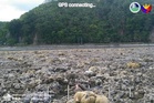
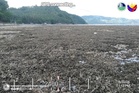
Residents reported a geological phenomenon known as “coastal uplift” after the quake, with the shoreline extending by as much as 200 metres in many places.
During the earthquake, the Cotabato trench off the southwestern coast of Philippines “pushed part of the coastlines of Sarangani and Davao [provinces]” and exposed the seabed that was originally submerged, Phivolcs said.
The seabed uplift has been estimated to be about 2 metres.
“Preliminary field observations indicate approximately 2 metres of coastal uplift and about 200 metres of shoreline retreat,” Phivolcs said.
In several regions, “formerly submerged corals are now exposed”, the agency said, adding that coastal landslides were also observed between the municipalities of Barangays Burias and Glan in Sarangani.
Images released by Phivolcs show large numbers of corals, seagrass, dead fish and other aquatic life on the exposed seafloor.
Independent analysis by experts also confirms that there has been a significant coastal uplift in the southern Philippines between 16 May and 10 June 2026.
“Indeed, it looks there is an extensive uplift that hasn't been observed previously on many dates,” geospatial analyst Sergio Augusto Jardim Volkmer posted on LinkedIn along with a map comparing sea levels between the two dates.
Earthquakes are a regular occurrence in the Philippines due to its presence along the Pacific “Ring of Fire” zone of fault lines and volcanoes.
Movement of the Cotabato Trench also caused the 1976 Moro Gulf earthquake and tsunami, which killed 8,000 people.
Seismic activity along the boundaries of the Philippine Sea Plate has produced seven major earthquakes of magnitude greater than 8, and 250 large ones of over 7 magnitude, as well as a number of tsunami-generating events, according to the US Geological Survey.
Read MoreDisaster drills helped prevent more deaths when powerful quake hit the southern Philippines
Philippines protests China's sanctions against its defense chief as 'an unfriendly act'
Europe's central bank raises rates to fight inflation from Iran war, the Fed to decide next week