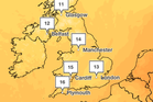
The first frost of autumn is set to arrive this week as temperatures take a seasonal tumble.
A chilly Arctic breeze will see the mercury plummet to near-freezing temperatures on Wednesday night and Thursday morning in northern England and Scotland.
Across the UK, the weather will feel noticeably cooler as a cold front brings fresher conditions, in a timely departure from September’s warmth.

Claire Nasir, Met Office meteorologist, said: “We do have rain spreading southwards and eastwards today, and fresher air moving in from the northwest with blustery showers.
“However through the afternoon and evening time, things will settle down. There will still be some coastal showers, but it will turn chilly inland in the early hours of Thursday morning.”
She added that temperatures across England and Wales “will be a lot lower than what we’ve been experiencing”, giving us the “first day across the UK where we haven’t seen 20C for quite some time - more than 115 days”.
Thursday morning “will turn cold wherever you are”, Ms Nasir said, as temperatures in towns and cities will drop to 5-6C, and even lower in rural spots.

Temperatures are set to climb up again to the high teens on Friday, the weekend is expected to see temperatures in the low- to mid-teens, with some sunny spells and cloud.
It comes after the UK recorded its joint-fourth warmest September ever, according to provisional figures from the Met Office.
The maximum temperature was as high as 28.1C on 29 September, the forecaster said, level with September figures from 1949 and 2016.
Experts have said wet and stormy conditions in autumn could develop into an icy winter as the “super El Niño” becomes the strongest in history.
El Niño is a naturally occurring climate phenomenon that develops in the tropical Pacific Ocean. It takes place when sea-surface temperatures across the central and eastern Pacific become significantly warmer than average, altering atmospheric circulation patterns and influencing weather around the globe.
Met Office five-day forecast
Tonight:
Rain clearing southeast England during the evening. Clear spells and showers elsewhere, with showers tending to become confined to coastal stretches overnight. Chilly, with a patchy frost in the north.
Thursday:
A chilly, though mostly sunny morning. Cloud increasing in the west, with rain moving in across western areas by the afternoon, with increasingly gusty winds in the north.
Outlook for Friday to Sunday:
Rain clearing to sunshine and blustery showers on Friday. Further showers on Saturday, with a drier day expected on Sunday. A little warmer on Friday then cooler for the weekend.
Read MoreAutumn finally arrives as colder temperatures to sweep UK this week
Experts give update on whether polar vortex could hit the UK this autumn
Where temperatures could hit 23C this weekend before cold chill
UK records one of its warmest Septembers on record, Met Office confirms
UK to enjoy up to 24C heat on Wednesday in ‘unseasonable’ September warm spell
Mapped: Where temperatures could hit 27C today in surge of warm weather across UK