A NASA-USGS satellite captured the eruption of Indonesia’s Anak Krakatau from orbit, recording volcanic gases and ash as the volcano entered one of its most disruptive eruptive periods in recent years.
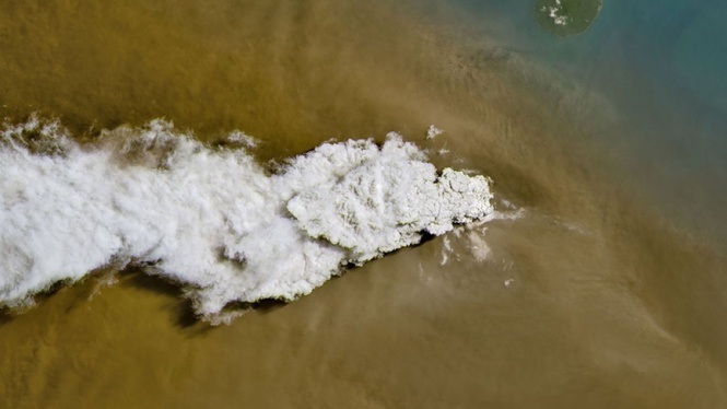
The Operational Land Imager aboard Landsat 8 photographed Anak Krakatau on Sept. 5, a day after the latest eruptive activity began. The image shows a white plume of volcanic gas rising from the island and a broader brown cloud of ash and debris spreading over the surrounding area.
NASA’s Earth Observatory said the white plume was composed largely of water vapor, carbon dioxide and sulfur dioxide. The satellite observation provides scientists with a view of the eruption and its plume over an area difficult to observe from the ground.
Anak Krakatau sits in the Sunda Strait between Java and Sumatra. The eruption intensified over the weekend, sending ash high into the atmosphere and disrupting air travel across parts of Indonesia.
Indonesia’s Geological Agency reported a continuous eruption lasting about 25 hours before the strongest activity subsided Sunday. The volcano remained active Monday, producing intermittent eruptions, ash emissions and small earthquakes.
Nearly 3,000 flights were halted as authorities closed airports because of the risk posed by volcanic ash. Ash can damage aircraft engines and other systems, making information on the location and movement of volcanic plumes important to aviation authorities.
Earth-observation satellites give scientists another way to follow such eruptions.
Landsat 8 carries the Operational Land Imager, or OLI, which records reflected sunlight in several wavelengths, including visible and near-infrared light. Those measurements allow researchers to distinguish features that can be difficult to identify from ordinary photographs.
The same satellite observed the eruption of Mayon Volcano in the Philippines earlier this year. A Landsat 8 image taken Feb. 26 showed lava, ash and gases from Mayon, with infrared observations helping reveal hot volcanic material against the surrounding landscape.
Satellite instruments are particularly useful for volcanoes in remote locations or when ash, weather or hazardous conditions restrict observations near an eruption. Repeated observations also allow scientists to compare changes in the volcano and surrounding terrain over time.
Landsat 8 is jointly operated by NASA and the US Geological Survey. Its observations form part of the Landsat program, which has collected images of the Earth’s surface for more than five decades.
Anak Krakatau has a particularly violent geological history. The island emerged from the caldera left by the 1883 eruption of Krakatau, one of the deadliest volcanic events in recorded history. Anak Krakatau, which means “child of Krakatau,” emerged above sea level in the late 1920s.
The volcano underwent a major collapse in December 2018 following an eruption. The collapse generated a tsunami in the Sunda Strait that struck nearby coastlines.
Indonesia has about 500 volcanoes, including 127 considered active, according to Space.com. The country lies along the tectonically active region called the Pacific Ring of Fire.