
MULTI-AGENCY fire suppression teams across Indonesia continue to battle stubborn forest and peatland blazes entering the final weeks of October, as satellite observations reveal extensive blankets of light-absorbing smoke particles drifting across Southeast Asia.
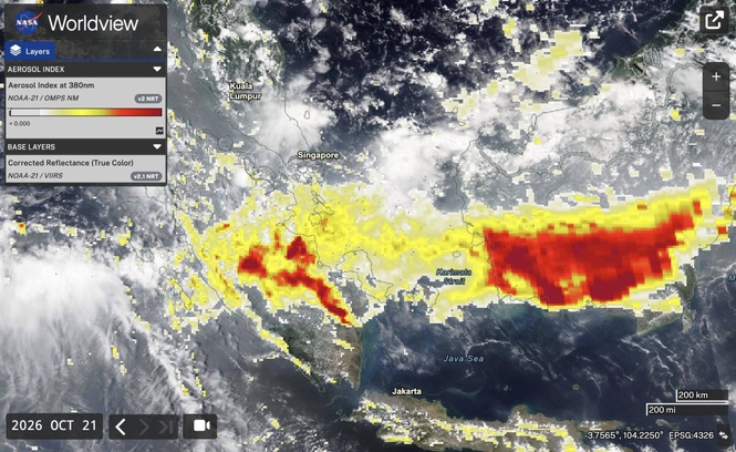
New Earth observation data published by NASA’s Earth Science Data and Information System (ESDIS) highlights the cross-border footprint of the disaster. Imagery captured by the Visible Infrared Imaging Radiometer Suite (VIIRS) aboard the joint NASA/NOAA-21 satellite recorded dense clusters of red thermal anomalies indicative of active fires and subterranean smoldering landscapes across Kalimantan.
Spectral analysis of the 380-nanometer ultraviolet aerosol index layer shows the deepest red colorations concentrated directly over burning peatlands in Kalimantan, with broader orange and yellow plumes marking particle-laden air drifting across the Malacca Strait toward Malaysia and Singapore. The UV aerosol index measures the height and concentration of airborne, light-absorbing particles such as soot, ash, and organic carbon.
Simultaneously, ground-based sensors in the Aerosol Robotic Network (AERONET) — specifically stations in Pontianak, Jambi, and Singapore — have logged high aerosol optical depth (AOD) values, signaling particle densities high enough to severely obscure sunlight and reduce visibility.
While emergency crews have subdued primary surface fronts across parts of South Sumatra, West Kalimantan, and Riau, emergency personnel report that hundreds of hectares remain actively burning or smoldering in Central Kalimantan and Jambi.
Independent satellite tracking from environmental monitor Nusantara Atlas shows that the cumulative burned area in Indonesia surpassed 1.9 million hectares through September, with fire activity roughly doubling in a single month as delayed monsoon rains and dry conditions left drained peatlands acutely vulnerable.
The climatic consequences extend well beyond regional public health. Preliminary figures from the Global Fire Emissions Database (GFED) indicate that the fires generated at least 76 million tons of carbon — equivalent to approximately 278 million tons of carbon dioxide — before entering the peak burn weeks of late September and October. With active smoldering persisting, seasonal emissions are projected to reach between 400 and 500 million tons of carbon dioxide equivalent, approaching levels seen during the severe 2019 fire crisis.
That volume introduces a significant wild card into international climate accounting.
The United Nations Environment Program’s (UNEP) latest Emissions Gap Report documented an overall 2.3 percent surge in global greenhouse gas emissions, representing an annual net increase of approximately 1.3 gigatons of carbon dioxide equivalent. The Indonesian peat fire season alone represents roughly a quarter to more than a third of that entire global net increase. In effect, subterranean combustion in a single archipelago threatens to offset the emissions avoided through years of investments in Southeast Asian solar, wind, and transport electrification.
The challenge lies in the nature of tropical peat. Drained by canals for agricultural concessions and smallholder plots, deep peat layers can burn meters underground without open flames. These low-temperature, smoldering blazes evade aerial water bombing and release heavy volumes of carbon monoxide, methane, and fine particulate matter (PM2.5). Indonesia’s Meteorology, Climatology, and Geophysical Agency (BMKG) has recorded PM2.5 concentrations exceeding the hazardous benchmark of 250.4 micrograms per cubic meter in several districts.
The drift has also triggered legal friction across borders. Singapore has invoked its Transboundary Haze Pollution Act, serving formal notices to several plantation operators holding concession lands connected to active fire signatures.
While BMKG forecasts project gradual monsoon rains developing across Sumatra and Kalimantan through late October and November, monitoring networks warn that until consistent rainfall saturates the water table and re-floods canal networks, smoldering peat beds will continue venting greenhouse gases and particulate haze across regional airspace.