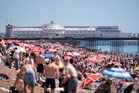
Saturday should offer a brief reprieve from the heat after parts of the UK sizzled in temperatures above 30C on Friday.
Fresher air from the west is expected to suppress temperatures slightly, although south-east England could still reach 27-28C.
Most areas will be dry with sunny spells and only a chance of isolated showers.
However, temperatures are forecast to rise again on Sunday, climbing further into Monday and Tuesday, as a Met Office amber warning for extreme heat takes effect.
The mercury is expected to hit 34C and potentially higher early next week.
The Met Office alert, in effect for Monday and Tuesday, covers London, the east and south-east of England, and sections of the south-west and Wales.
The warning highlights potential health impacts for those vulnerable to extreme heat, broader heat-related issues for the population, and an increased risk of water safety incidents.
This alert differs from the amber heat health alerts issued by the UK Health Security Agency (UKHSA).
Will there be a weekend heatwave?
A heatwave threshold is likely to be met across southern and eastern England on Sunday, with forecasters indicating a 40 per cent chance of exceeding June's highest-ever temperature of 35.6C, recorded in 1957 and 1976.
Some areas in the south and south-east of England are forecast to reach 32C on that day and then push up or above 34C on Monday.
They are again likely to reach the mid-30s on Tuesday.
Some locations may see temperatures remain above 20C overnight on Monday and Tuesday, particularly in urban areas.
Amber heat health alerts are in force by the UKHSA for the east, south-east and south-west of England, as well as London, until 8pm on Tuesday.
Greg Wolverson, deputy chief forecaster at the Met Office, said: “While heatwave criteria will be met for some in the south and south-east of England over the weekend, with temperatures into the low 30s possible, the warmth will expand and intensify at the start of next week, which, coupled with high temperatures overnight, leads to potential impacts.
“Temperatures will peak around the mid-30s on Monday and Tuesday. The humidity will also mean this feels close, warmer and more uncomfortable for many.
“Tropical nights – where the temperature doesn’t drop below 20C – are also likely for some.”
The warmth may bring some thundery downpours for some on Monday and Tuesday, though these should be “fairly isolated”, the Met Office said.
The very high temperatures could continue across a smaller part of the country into the middle of the week, but this remains uncertain for now, the forecaster added.
At least 15 people died after getting into trouble in open water during a hot spell in May.
Samantha Hughes, national water safety partner at the Royal National Lifeboat Institution, said: “With warmer weather approaching, it’s important to remember that the water is still cold.
“Entering it unexpectedly can lead to cold water shock, causing a sudden increase in breathing and heart rate, which may trigger panic.”
After the heat health alerts were issued, the Health and Safety Executive (HSE) said employers must ensure their workers are protected while maintaining productivity during the heatwave.
Read MoreWhat is a heat dome? How Europe’s scorching temperatures are driving the UK heatwave
Met Office issues amber weather warning for extreme heat ahead of UK heatwave