A dirty-looking “iceberg” in the Weddell Sea turned out to be something fixed, rocky, and missing from available charts. When scientists aboard the German research icebreaker Polarstern moved closer, they realized the object ahead of them was not drifting ice.
It was an uncharted island.
The finding came during a 2026 Antarctic expedition led by the Alfred Wegener Institute, Helmholtz Centre for Polar and Marine Research. In an official AWI press release, the institute said a 93-person international team had been working in the northwestern Weddell Sea since February 8, 2026, when rough weather forced the ship to interrupt its research and seek shelter near Joinville Island.
That route change brought the crew near a spot that nautical charts had not shown as land. Instead, the area was marked as a danger zone, meaning the charts warned of possible hazards without clearly identifying what was there.
A Storm Detour Led Polarstern Toward Unmapped Land
The Polarstern expedition was not organized to find new islands. AWI said the research mission was focused on the outflow of ice and water from the Larsen Ice Shelf, as well as recent sea ice retreat in a region connected to global ocean currents.
But rough weather changed the ship’s immediate plan. The team sought shelter in the lee of Joinville Island, and that decision put Polarstern close to the charted danger area.
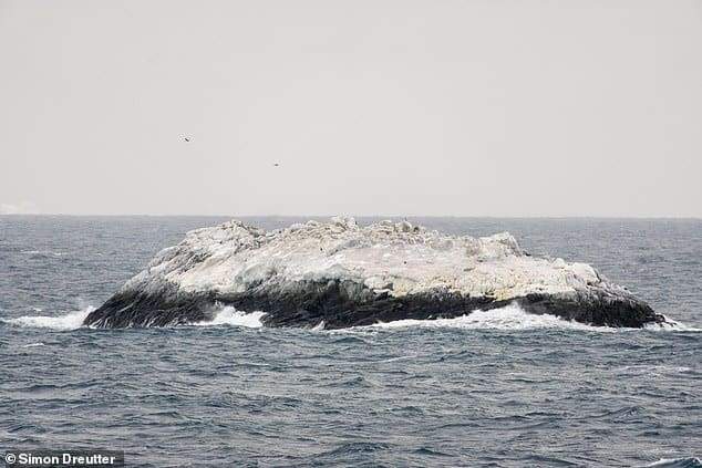
Simon Dreutter, a bathymetry specialist at AWI, said the nautical chart showed “unexplored dangers to navigation,” but it was unclear what the danger was or where the information had come from. Looking from the bridge, the crew first saw what seemed to be a dirty iceberg. A closer look suggested rock.
The ship changed course toward the object. As it approached, the team realized it had an island in front of it.
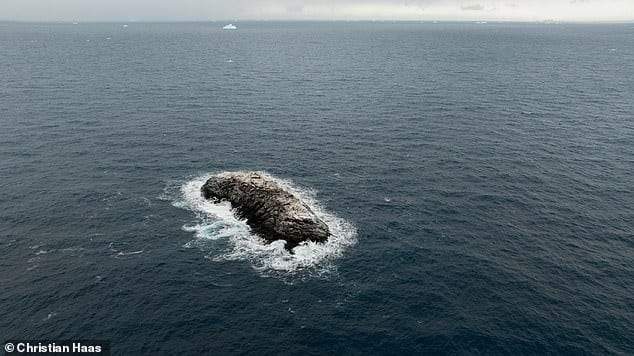
The Island Was Measured by Sonar and Drone Imagery
AWI said the ship approached carefully, always keeping at least 50 meters of water under the keel. Polarstern came within about 150 meters of the island, circled it, and surveyed the surrounding seabed with an onboard multibeam echo sounder.
The team also used a drone. Its image data was analyzed through photogrammetry, a method that uses overlapping photographs to measure shape, elevation, and position. That helped the researchers produce an elevation model and a georeferenced aerial image of the coastline.

According to AWI, this was the first time the island had been systematically surveyed and recorded. The result was specific: the island is about 130 meters long, 50 meters wide, and rises about 16 meters above the water.
Those dimensions make it slightly longer than Polarstern itself, which AWI gives as 118 meters long, and about twice as wide. It is not a continent-changing discovery, but it is large enough to matter for ships operating in a remote polar region where sea ice, weather, and limited chart detail already make navigation difficult.
Why the Island Was Hard to See From Space
The puzzle is not simply that an island existed. The harder question is why it appeared as a danger on nautical charts but not as a mapped coastline in other datasets.
AWI said experts still do not know why the island was marked only as a danger zone, why it was missing as coastline elsewhere, or why the position shown on the nautical chart was about one nautical mile away from the island’s actual location.
Satellite images did not settle the matter easily. The island’s ice cover made it difficult to distinguish from the numerous icebergs drifting nearby. In the Antarctic, a white or grey shape surrounded by ice does not automatically read as fixed land from above.
That detail is important because it keeps the story grounded. The finding does not prove that large parts of Antarctica are unmapped in a dramatic sense. It shows that small, ice-covered coastal features can still slip through available datasets, especially in regions where direct measurements are sparse.
The issue also connects to how Antarctic seafloor and coastal data are compiled. AWI said the island’s information is essential for bathymetric seafloor maps such as the International Bathymetric Chart of the Southern Ocean, because thin measurement coverage and interpolation can cause unmapped objects to disappear from mapped products.
The broader challenge of polar mapping is also reflected in U.S. Geological Survey material on the Antarctic region and mapping data, which points to the role of coordinated scientific information in understanding the continent and surrounding Southern Ocean.
The Island Now Has to Enter the Official Record
The island has not yet received an official international name. AWI said the team must now go through the naming process for this kind of discovery.
Once that process is complete, the researchers plan to publish the exact position and ensure the information is added to nautical charts and other important datasets. That step matters more than the island’s name alone, because ships need accurate chart data in waters where hidden hazards can be difficult to identify visually.

The expedition also reported observations of Antarctic sea ice in the northwestern Weddell Sea, including strong regional differences in ice thickness and signs of surface melting. AWI said future analysis and modeling will follow after the expedition.