For centuries, maps of Earth showed seven continents. That number has quietly been under challenge since 2017, and the case for changing it is built on hard geological data, not theory.
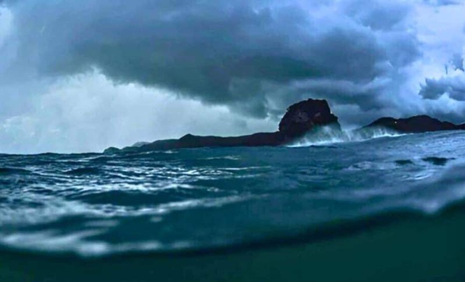
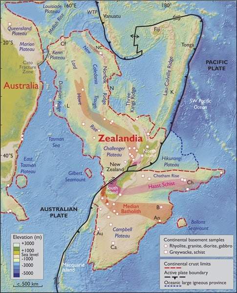
Beneath the southwest Pacific Ocean lies a landmass nearly 1.9 million square miles across, larger than India, two-thirds the size of Australia. It has its own crustal structure, its own tectonic history, and fossil evidence of dinosaurs that lived on its surface long after it began to sink. Almost none of it is visible today. Only New Zealand, New Caledonia, and a handful of smaller islands break the surface. The rest sits submerged, up to 94 percent of it hidden beneath the ocean.
Its name is Zealandia, and in March 2017, a team of eleven geologists published a formal case in the Geological Society of America’s journal GSA Today arguing that it is not a fragment, not a microcontinent, not a loose collection of submerged islands. It is Earth’s eighth continent.
What Makes Zealandia a Continent
For decades, the region was written off as scattered continental crust. What changed the assessment was technology. Advances in satellite gravity mapping, seafloor elevation data, and deep-sea drilling allowed researchers to map the full structure of the submerged landmass with a precision earlier surveys could not achieve.
What they found cleared every standard geological test. Zealandia sits at a distinct elevation above the surrounding ocean floor. It contains diverse, silica-rich rocks characteristic of continental masses rather than the basalt typical of oceanic plates. Its crust averages 20 kilometers thick, far greater than the roughly 7 kilometers of oceanic crust, though thinner than most other continents. Its underwater terrain of ridges, plateaus, and basins outlines a continuous, unified landmass.
The 2017 authors were direct: “Zealandia is not just a collection of continental fragments. It is a coherent continent and should be recognized as such.” That statement, published in GSA Today, remains the strongest peer-reviewed argument for its status.
The idea had a much earlier origin. In 1995, geophysicist Bruce Luyendyk first proposed the name Zealandia for the submerged region, sparking renewed interest in how it should be classified. And further back still, Scottish geologist Sir James Hector presented evidence in 1895 that New Zealand was the remnant of a submerged continental ridge. His findings were largely ignored at the time.
How a Continent Sank Beneath the Sea
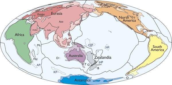
Zealandia was once part of Gondwana, the ancient supercontinent that held Antarctica, Australia, South America, Africa, and the Indian subcontinent together in a single mass. As Gondwana began breaking apart more than 100 million years ago, Zealandia separated from what is now eastern Australia and underwent extensive tectonic stretching. That geological strain caused its crust to thin, and the landmass gradually sank.
Some researchers estimate the submersion began around 85 million years ago, with full submersion possibly complete by 25 million years ago, though others argue parts of it remained above sea level considerably longer.
The fossil record supports that longer timeline. In New Zealand and the Chatham Islands, bones from sauropods, ankylosaurs, and possibly allosaur-like dinosaurs have been found. These species lived after Zealandia had already separated from Gondwana, suggesting sections of the continent remained habitable for millions of years after the breakup. A dinosaur-era foot bone discovered on the Chatham Islands, highlighted in BBC Future’s investigation into Zealandia, raised further questions about what else may lie buried under the seafloor.
In 2017, an international team aboard the research vessel JOIDES Resolution drilled more than 4,000 feet into the seabed at six sites across Zealandia. The cores they recovered contained pollen, spores, and microfossils typically associated with shallow marine or terrestrial environments, direct evidence that significant portions of Zealandia were not always underwater.
Economic and Scientific Stakes
The recognition of Zealandia carries consequences beyond geology. Under the United Nations Convention on the Law of the Sea, countries can claim an extended continental shelf beyond their standard Exclusive Economic Zones if they can demonstrate geological continuity.
New Zealand’s claim, backed by Zealandia’s confirmed extent, could significantly expand its access to marine mineral resources, seabed mining rights, and hydrocarbon reserves.
The scientific implications reach further. Zealandia forces a reexamination of plate tectonics and continental drift, particularly in cases where landmasses have been deformed or submerged over geological time. Its crustal properties make it a direct case study in how continents evolve under sustained tectonic pressure.