The 5-magnitude earthquake that shook the Dhauladhar region on the night of June 5 has once again drawn attention to the fragile geology of the Kangra valley and the growing risks posed by unregulated construction in one of India’s most seismically active regions.
At 10.04 pm, the tremor rattled homes across Palampur and surrounding areas, sending anxious residents rushing outdoors. Though the earthquake lasted only a few seconds and caused no major damage, seismologists and disaster management experts say it should be viewed as a warning rather than an isolated incident.
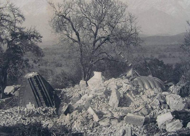
The Kangra valley and the Dhauladhar ranges fall in a high seismic risk zone and have a long history of destructive earthquakes. The most devastating among them was the Great Kangra Earthquake of April 4, 1905, which measured an estimated 7.8 to 7.9 on the Richter scale. More than 20,000 people lost their lives, over one lakh buildings were destroyed and several historic structures, including the Kangra Fort and Brajeshwari Temple, suffered extensive damage.
Despite this history, rapid urbanisation continues across the region. Multi-storey hotels, commercial complexes and residential buildings are increasingly coming up on fragile hill slopes, raising concerns among experts about the safety of large-scale construction in ecologically sensitive and geologically unstable areas.
The region has experienced several significant earthquakes since 1905. A magnitude 6.4 earthquake struck Kullu in 1906, while a 6.8-magnitude quake in Kinnaur in 1975 caused widespread destruction and loss of life. On April 26, 1986, a 5.5-magnitude earthquake shook Dharamsala and Palampur and the 6.8-magnitude Chamoli earthquake of March 1999 in neighbouring Uttarakhand was strongly felt across Himachal.
Experts point out that traditional Himalayan architecture had evolved over centuries to cope with seismic activity. Construction techniques such as Kath-Kuni, which combines layers of wood and stone and Dhajji-Dewari, which uses timber frames filled with masonry, provided flexibility during earthquakes and reduced the risk of structural collapse.
They argue that modern construction practices can benefit significantly from incorporating principles derived from these traditional building systems.
Equally important, experts say, is the regulation of construction on steep slopes. Extensive hill cutting to accommodate heavy concrete structures weakens slope stability and increases the likelihood of landslides during earthquakes and periods of intense rainfall.
They stress that building heights, structural loads and land-use planning must be determined in accordance with the carrying capacity and geological characteristics of the terrain.
While the recent earthquake caused little damage, it has revived memories of the region’s seismic vulnerability and raised fresh questions about preparedness and sustainable development in the Himalayas.
More than a century after the catastrophic 1905 Kangra earthquake, experts say the challenge remains the same: ensuring that development proceeds in harmony with the region’s geological realities rather than in defiance of them.