TECHNOLOGY is playing an increasingly important role in helping humanitarian organizations prepare for, respond to and recover from disasters. From AI-powered analysis of satellite and drone imagery to cloud-based platforms that enable real-time collaboration, digital tools are helping first responders and aid agencies make faster, more informed decisions when lives are at stake.
Across the global humanitarian sector, organizations are using AWS technologies for life-saving work in disaster response, climate resilience, health care, education and other areas. Through initiatives such as the Now Go Build CTO Fellowship, AWS supports nonprofit and social impact organizations with access to technical training, cloud expertise and mentorship to find innovative solutions to some of the world’s most pressing challenges.
When being ‘off the map’ is a matter of life and death
Crisis mapping is one area that has a significant impact on the effectiveness of disaster response. In many parts of the world, vulnerable communities don’t exist on digital maps. No roads. No buildings. No infrastructure. When disaster strikes, that invisibility can be catastrophic.
AI is increasingly being harnessed to change this equation. Two organizations helping address this challenge are Help.NGO and Humanitarian OpenStreetMap Team. Both are using innovative, AI-enabled crisis mapping technologies to transform frontline disaster response.
Turning data into decisions in disaster zones
As the international community continues to increase its capacity to respond to crises, organizations such as Help.NGO are leading the way. From hurricanes in Mexico and wildfires in the Amazon region to earthquakes in Türkiye and war in Ukraine, its specialist emergency response team is harnessing rapidly evolving technologies to help humanitarian agencies, local leaders and first responders act swiftly and efficiently.
The Philippines is also one of Help.NGO’s key operational hubs, with a significant part of its team based in the country for many years. This long-standing local presence has enabled the organization to build partnerships with local governments, universities, civil society organizations and disaster response groups while developing solutions tailored to the needs of communities across the country.
Help.NGO Operations Director Aleksandra (Ola) Bilicka explains, “We focus on imagery and connectivity, but also humanitarian security. By empowering first responders, we help them work smoothly and ensure beneficiaries receive the best possible aid.”
A key part of this work is expanding connectivity in remote and disaster-prone areas, where reliable communications can be crucial during emergencies. In Barangay Dikapanikian, Dingalan, Aurora, Help.NGO established low Earth orbit (LEO) satellite connectivity that provides public Wi-Fi and serves as the community’s only functioning communication link to the municipal government when cellular networks become unavailable during typhoons and heavy rainfall. This allows officials to relay updates, request assistance and coordinate emergency response. In Catanduanes, similar connectivity initiatives have supported essential facilities and community organizations, including the provincial disaster risk reduction and management office, health care facilities and fisherfolk communities.
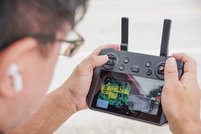
Beyond connectivity, Help.NGO has also deployed drone technology to provide real-time disaster intelligence. In the wake of an emergency, infrastructure is often damaged or destroyed. Communication networks fail. Roads disappear. Landscapes shift.
Bilicka and her team support local aid workers in capturing aerial imagery and then assist with the challenge of processing and interpreting that data quickly. Using AWS technologies, teams on the ground can upload and process terabytes of drone imagery, transforming raw data into a comprehensive situational analysis regardless of cloud access. Even in environments with limited or unreliable connectivity, private 4G/5G networks and AWS Outposts enable on-site data processing, helping teams generate actionable intelligence within hours rather than days. Crisis mapping is further enhanced by AI and generative AI models that analyze terrain, assess impact, make predictions and issue warnings.
The application of these capabilities extends beyond emergency response. In the Philippines, Help.NGO has worked with Visayas State University to develop an AWS-based geospatial workflow for processing drone imagery to support agricultural research and precision agriculture. The organization has also worked with Catanduanes State University on drone mapping projects to support mangrove monitoring and restoration planning.
Together, these efforts demonstrate how technology, connectivity and local expertise can strengthen the capacity to prepare for and respond to crises. In situations where every second counts, access to reliable communications and timely geospatial information can help first responders make more informed decisions and coordinate assistance when it matters most.
Putting invisible communities on the map
In parallel, the Humanitarian OpenStreetMap Team (HOT) is addressing a foundational challenge: ensuring that missing maps are no longer a barrier to effective disaster response. In many high-risk regions, critical geospatial datasets, such as road networks and building footprints, are incomplete, outdated or unavailable. From needs assessments to route planning, these gaps inhibit humanitarian efforts at every turn.
HOT originated in 2010 following the Haiti earthquake, when hundreds of humanitarian organizations arrived in the country ready to help, only to find that there were no updated maps. Without reliable geographic information, coordinating resources, locating isolated communities or planning safe routes was nearly impossible.
Since then, HOT has supported more than 170 disaster activations, helping local communities around the world affected by hurricanes, landslides, floods and wildfires that threaten lives and access to essential services. Its global volunteer network of mappers rapidly generates geospatial data using HOT’s AWS-enabled Tasking Manager, which creates reliable maps trusted by governments, NGOs and humanitarian organizations around the world.
Petya Kangalova, tech partnership and engagement lead at HOT, says, “The rising impact and scale of humanitarian emergencies on vulnerable populations makes the demand for data-driven disaster response as urgent as ever. Until recently, crisis mapping has been extremely labor-intensive, but with AI-assisted mapping tools, we can produce detailed, accurate maps in a fraction of the time. By analyzing drone and satellite imagery to detect buildings, roads, and infrastructure, we can provide first responders with critical information to take more informed and locally appropriate action before, during, and after a crisis hits.”
The real strength here is the combination of open data and local expertise. HOT empowers communities through localized training and education initiatives, enabling them to build technical capabilities that sustain mapping efforts over time. For example, in places such as Sierra Leone, where dense settlements make mapping particularly complex, community members identify critical infrastructure, such as hospitals, ensuring maps reflect on-the-ground realities. Mapping is no longer something done to communities; it is done with them.
Humanitarian impact in the most remote places on Earth
Organizations such as Help.NGO and the Humanitarian OpenStreetMap Team are operating in some of the most challenging conditions imaginable: limited resources, unpredictable environments and immense pressure to deliver outcomes that can mean the difference between life and death. They are turning constraints into innovation, using AI to enhance early warning systems and bring visibility to communities that have long been overlooked.
Their work highlights the role technology can play in building resilience in the world’s most vulnerable regions.
Crisis mapping is just one example, but it highlights a broader shift. As the scale and frequency of humanitarian crises continue to grow, collaboration among technology providers, nonprofit organizations, local communities and first responders will become increasingly important. By working together, we can ensure that no community is invisible, no voice is unheard and no life is beyond reach.
Precious Lim is the country manager for the Philippines at Amazon Web Services (AWS), Amazon’s cloud computing business, providing organizations with services for data storage, computing, artificial intelligence, analytics and digital infrastructure over the internet.