After Thursday night’s intense thunderstorm under a red alert and Friday’s orange alert that delivered only scattered rain and brief spells of gusty weather, Saturday’s yellow alert too passed without any major impact across Chandigarh, Mohali and Panchkula, indicating a gradual weakening of the active weather system over the region.
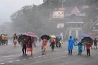
The only significant weather activity was witnessed in the early hours of Saturday when loud thunderclaps, lightning, gusty winds and scattered showers swept across parts of the Tricity around 2.30 am. The spell continued intermittently for nearly two to three hours before subsiding. The rest of the day remained largely dry, with overcast skies, pleasant conditions and a light breeze replacing the heat that had gripped the region just a week ago.
According to the India Meteorological Department (IMD), no weather alert or warning has been issued for Chandigarh and adjoining areas beyond Saturday. However, isolated light showers and localised thunderstorm activity cannot be ruled out over the coming week as residual moisture continues to linger over northwestern India.
The cooling effect of the recent wet spell remained evident in temperature readings. Chandigarh recorded a maximum temperature of 32.1°C, which was 6.5 degrees below normal, while the minimum settled at 21.4°C, nearly 5 degrees below normal. Mohali recorded a maximum temperature of 32.1°C and a minimum of 22.5°C. IMD data showed that both day and night temperatures remained significantly lower than seasonal averages across much of Punjab and Haryana.
The weather office reported light to moderate rainfall at many places in Punjab and Haryana during the preceding 24 hours, accompanied by thunderstorms, lightning and gusty winds at isolated locations. Punjab’s average maximum temperature fell another 2.1 degrees Celsius and remained a substantial 8.2 degrees below normal, underlining the extent of relief from the prolonged heat.
For Tricity, the IMD has forecast partly cloudy skies with the possibility of isolated rain or thundershowers on Sunday, followed by mainly clear skies from Monday onward. Maximum temperatures are expected to hover between 36 and 37°C during the next five days, while minimum temperatures are likely to gradually rise from 22°C to around 25°C.
“The active weather phase that produced thunderstorms, squally winds and widespread cloudiness over the past several days is now weakening and shifting eastwards. While no major weather event is expected over Chandigarh, Mohali and Panchkula in the immediate future, sufficient low-level moisture remains available to trigger isolated showers, particularly during late evening or early morning hours,” an IMD meteorologist said.
The meteorologist said the recent rainfall has substantially lowered temperatures and improved atmospheric comfort levels, effectively keeping heatwave conditions at bay for the foreseeable future. However, with clearer skies expected next week, temperatures are likely to witness a gradual rise, though they are expected to remain close to or slightly below normal for mid-June.
For residents, the week ahead is expected to bring relatively pleasant pre-monsoon weather, with occasional cloud cover and isolated rain chances replacing the severe thunderstorm threats that dominated weather forecasts earlier this week.