.jpeg?width=1200&auto=webp&trim=0%2C186%2C0%2C185)
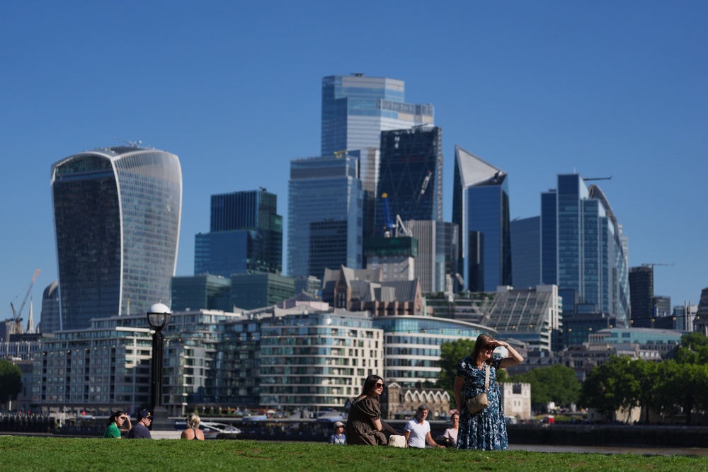
Parts of England are set to swelter in a fresh heatwave this weekend, with temperatures hotter than Ibiza on Sunday.
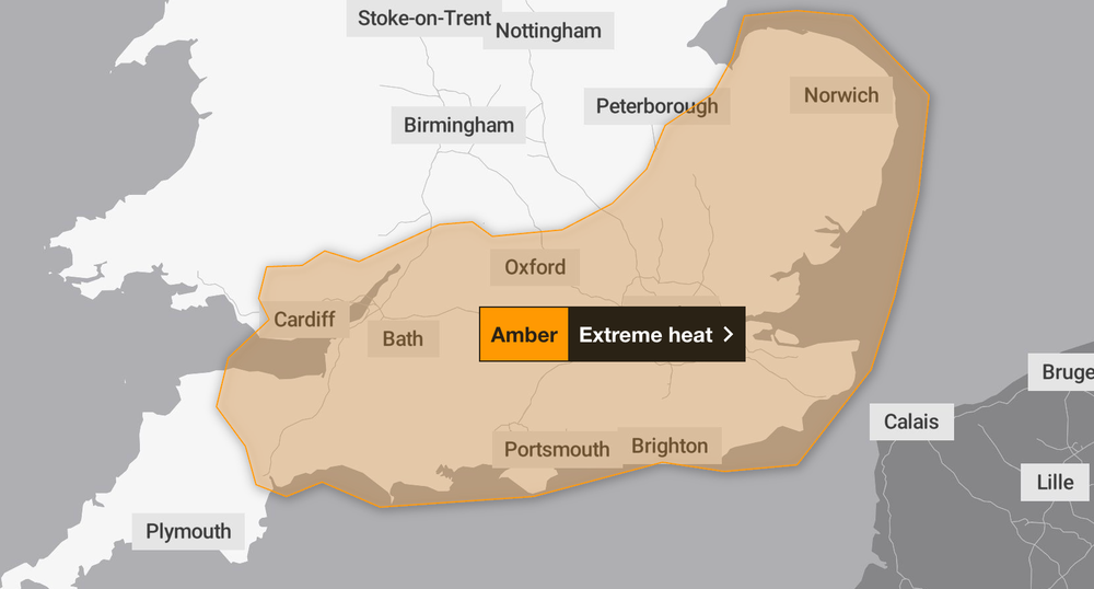
The Met Office has issued an amber weather warning for extreme heat in the East of England, London and South East England, South West England, and Wales on Monday and Tuesday as temperatures are set to reach a sweltering 37C.
It comes after series of UK Health Security Agency amber heat health alerts were issued for the South East, the East of England, London, the Midlands and the South West. The amber alerts, which warn of increased demand on health and care services, start on Monday and continue until 11pm on Wednesday.
UKHSA also issued yellow alerts for the North East, North West and Yorkshire and The Humber, which means a greater risk to the lives of vulnerable people.
On Sunday, London and the South East could reach 32C, with conditions becoming hot and humid. In the South West of England, Sunday will be a largely dry and bright day with temperatures reaching 28C.
In the North East and North West of England, Sunday will be mainly dry with cloudy skies and onshore winds keeping the coastal areas cooler. Temperatures will mainly be in the low 20s.
It will be a bit warmer in the Midlands on Sunday, with the mercury climbing to 27C - hotter than the Spanish archipelago Ibiza.
The weekend heat will precede unusually high temperatures on Monday and Tuesday. The current highest temperature on record for June is 35.6C and there is a chance that this record could be broken next week.
Dr Agostinho Sousa, head of extreme events and health protection at UKHSA, said: “Sustained periods of warm weather can result in serious health outcomes, especially for older adults, and it is therefore important that everyone takes sensible precautions while enjoying the sun.
“We are urging health and social care services in affected regions to ensure they are prepared, and reminding people to look out for elderly relatives, neighbours, and those with underlying health conditions, making sure they are aware of the forecast and following the necessary advice.”
A UK heatwave threshold is met when a location records at least three consecutive days on which daily maximum temperatures meet or exceed the heatwave temperature threshold. The threshold varies by UK county. In London and the South East, that threshold is 28C or 27C.
Sunday weather
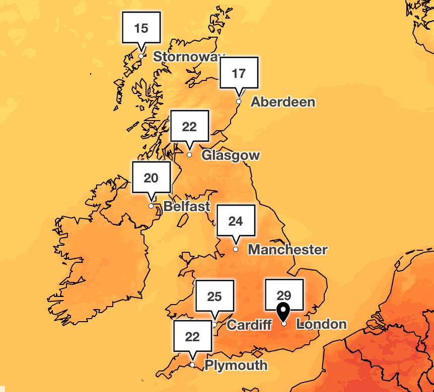
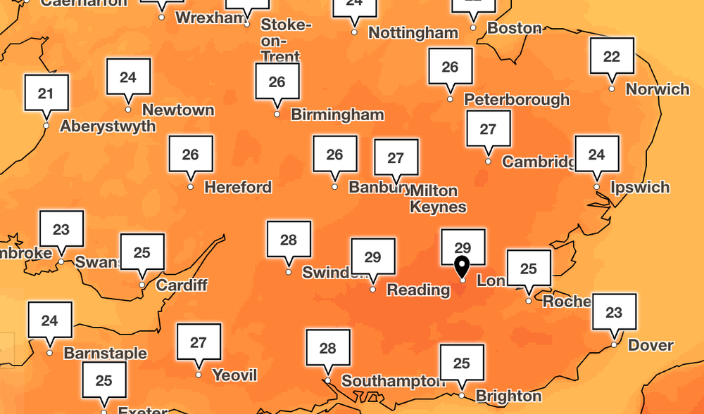
On Sunday, London and southeastern areas are due to see a return to 30C, while other areas of England and Wales will experience temperatures reaching around 25C.
Temperatures will stay in the mid-teens for the northern parts of Scotland, but could climb above 20C in the southern areas.
Much of Northern Ireland will approach 20C on Sunday afternoon.
Samantha Hughes, the National Water Safety Partner at the RNLI, said warned swimmers of the risks of cold water shock even when it is sunny and warm.
She said: “With warmer weather approaching, it’s important to remember that the water is still cold. Entering it unexpectedly can lead to cold water shock, causing a sudden increase in breathing and heart rate, which may trigger panic.
“If you find yourself struggling in the water, remember to Float to Live: tilt your head back so your ears are submerged, relax and control your breathing. You may need to gently use your hands to help you stay afloat, and it’s ok if your legs sink - everyone floats differently.”
Monday and Tuesday heatwave
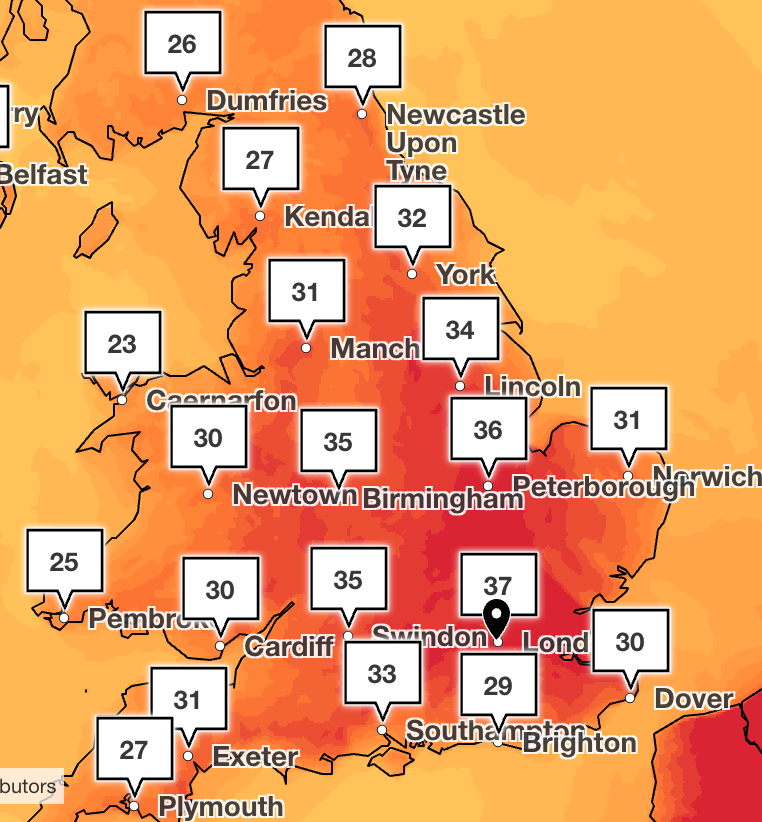
The weather is set to get hotter for most of the country on Monday, with 32C forecast in the southeast. Another scorching day is expected on Tuesday, when temperatures could climb to 37C.
A Met Office amber warning for extreme heat will come into force at 1am on Monday, as the forecaster warns very high temperatures will likely bring widespread impacts to people and infrastructure. It will be lifted at the end of the day on Tuesday. There is a chance of occasional low cloud along the coasts and isolated thunderstorms on Monday.
Experts at the Met Office said that there was some uncertainty about how long the highest temperatures will continue due to increasing cloud and thunderstorm risk.
What is a heat dome and why is it influencing the UK’s weather?
A heatwave developing in the UK and across Europe has been influenced by a strong area of high pressure that is currently on the continent.
The high-pressure system promotes widespread sinking air over the region and traps hot air underneath it, acting like a lid on a pot and creating a “heat dome”.
Parts of Spain, France and Italy are expected to see temperatures rise into the high 30s, and possibly exceed 40C over the coming days.
Last month, the UK sweltered in an early summer-style heatwave, during which at least 15 people, including children, died in open water.
Mr Wolverson said: “This week’s weather reflects a contrast we often see in summer, with more unsettled conditions passing to the northwest of the UK while heat builds in the South and East.”
Meteorologist Jonathan Vautrey warned rising temperatures and humidity would be likely to come with overcast skies for many.
Read MoreEngland fans arrive in Boston as city bids farewell to Tartan Army
Royal Mail launches campaign inspiring children to send World Cup support letters
UK boosts wildfire defences with £97m nvestment for firefighters and climate threat
Bedford train crash latest: Injury toll rises to 100 as investigators look into cause
Three men dead following fire in west London building
Teenagers have strong views on the social media ban – just not the ones you think