WHEN the Cotabato Trench ruptured on June 8, 2026, the magnitude 7.8 earthquake it unleashed did more than shake buildings and trigger aftershocks. It physically reshaped the coastline of southern Mindanao.
Entire stretches of coral reef in Sarangani and Davao Occidental were lifted abruptly out of the sea, leaving once‑submerged marine sanctuaries exposed to the sun. In some areas, the shoreline jumped outward by nearly 200 meters. What residents witnessed in minutes was the surface expression of a deep tectonic process that had been building for decades.
PhilSA satellite data generated maps showing shoreline shifts in Barangays Burias and Pangyan, Sarangani, confirming the coastal uplift following the earthquake. In the maps, the shoreline (yellow pre-earthquake, red post-earthquake) is defined as the boundary of the exposed sand. Delineated in green are possibly exposed underwater features.
The shorelines were delineated using visual interpretation and Automated Water Extraction Index (AWEI) analysis of Sentinel-2C satellite imagery acquired on May 10 and June 9, 2026. PhilSA said the maps are subject to ground validation.
The Cotabato Trench marks the western boundary of the Philippine Mobile Belt, a geologically restless region squeezed between the Philippine Sea Plate on one side and the Eurasian and Sunda plates on the other. Off the coast of Mindanao, the oceanic crust of the Celebes Sea — part of the Sunda Plate — dives beneath the Cotabato segment of the Mobile Belt. This slow but relentless subduction, moving at several centimeters per year, is the engine that drives the region’s largest earthquakes.
For years, the interface between these two plates had been locked by friction. As the Celebes Sea Plate continued to descend, the overriding Philippine Mobile Belt bent and accumulated strain, much like a wooden plank pressed downward at one end. On June 8, that locked segment finally gave way. The sudden rupture allowed the overriding plate to rebound upward and outward, releasing the stored energy in a single violent motion. This elastic snap is what produced the two‑meter rise of the seafloor and the dramatic uplift of the coastline.
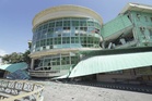
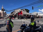
The effects were most visible in Glan, Sarangani, and in the coastal villages of Jose Abad Santos, Davao Occidental. Coral heads that had grown for centuries at stable depths were suddenly stranded above the high‑tide line. The Pangyan Marine Sanctuary, once a thriving underwater habitat, now sits exposed as a stark reminder of how quickly tectonic forces can redraw the boundary between land and sea. Scientists classify this as co‑seismic uplift — an instantaneous vertical shift caused directly by the earthquake. While the crust may undergo minor settling in the months ahead, the overall elevation change is expected to remain permanent on any human timescale.
The June 8 earthquake did not occur in isolation. From January to May, a prolonged swarm of small earthquakes rattled parts of Sultan Kudarat and nearby provinces. Seismologists are now studying whether these earlier tremors were linked to deeper movements along the subduction zone, possibly involving migrating fluids or slow, silent slip at depth. Such processes can alter stress conditions on the shallower, locked portion of the megathrust, potentially nudging it closer to failure. Although the connection is not yet confirmed, the timing has drawn scientific interest.
More than 5,000 aftershocks have been recorded since the mainshock, and these tremors are providing valuable clues about the geometry of the rupture. By mapping where aftershocks cluster, researchers can infer the size, shape, and angle of the fault plane that slipped. This information will help determine whether the released stress has shifted toward neighboring segments of the Cotabato Trench, including the northern portion associated with the catastrophic 1976 Moro Gulf earthquake and the 2002 Mindanao event. Understanding this stress transfer is essential for assessing whether other parts of the trench may now be closer to failure.