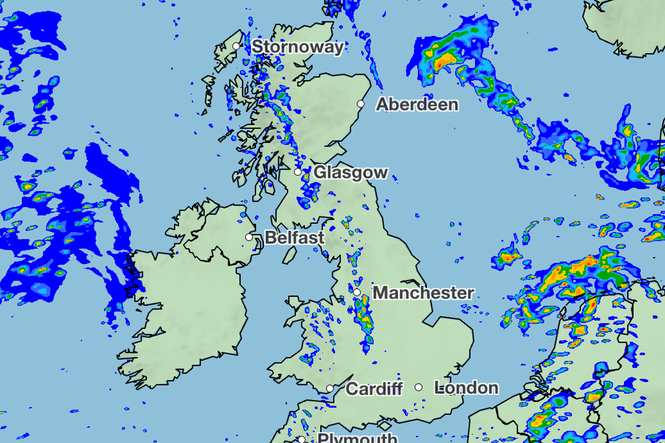
The weather is set to brighten up on bank holiday Monday, with sunny and dry interludes forecast for much of the UK.
Following thunderstorms and heavy showers across the weekend, the final day of summer is expected to bring more settled conditions, the Met Office said.
It marks the end of one of the driest summers to date, in which the UK broke several temperature records and suffered through five heatwaves.
Meteorologist Kathryn Chalk said: “We’ve had low pressure, but that’s clearing its way out towards the North Sea, so it will turn brighter and there will be more in the way of sunshine for eastern parts of the UK.
“From the west, some showers will bubble up, especially across the south east of England, and there is likely to be showers later today.
“The odd rumble of thunder can’t be ruled out, but towards the west we have a ridge of high pressure extending, so that will help fade the showers to leave a largely settled afternoon to come.”
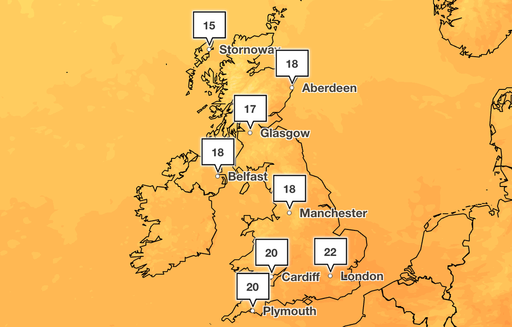
She said temperatures will return to average for most of the country, with a high of 22C forecast in the capital.
In southern and eastern parts of England, temperatures are set to climb above 20C, while Wales and northern England will experience highs of around 19C.
The Met Office has forecast slightly cooler temperatures in Scotland and Northern Ireland on Monday, where highs of around 17C are expected in several areas.
Showers will ease on Monday evening, and clear spells will develop across England and Wales for Tuesday, the weather agency added.
“It will be a bright start across England and Wales into Tuesday with a good deal of blue skies and a few showers around in the west,” Ms Chalk said.
Forecast for the next five days
Today
Many areas are starting dry with variable amounts of cloud, although showers already affecting western areas will become more widespread. These showers will be locally heavy, with the odd rumble of thunder. It will become drier from the west later.
Tonight
A few showers across the north and west will merge overnight to give some longer spells of rain. Elsewhere, it will become largely dry with clear spells.
Tuesday
Dry and settled across much of England and Wales, with variable amounts of cloud. Cloudier elsewhere, with a band of rain affecting Scotland, which will sink southwards during the day.
Outlook for Wednesday to Friday
Remaining changeable with showers or longer spells of rain for most, although some drier and brighter spells also developing. Temperatures near normal for early September, although often mild by night.
Will there be a thunderstorm today? Bank Holiday forecast after UK doused by rain
Fresh thunderstorm warnings issued for 64 areas amid flooding concerns – full list
People urged to prepare ‘emergency kit’ as Met Office warns of floods and storms
Schools need to change for good to help children cope with heatwaves – here’s how
Large parts of UK under thunderstorm and flood warnings today – full list of regions
Mapped: Where thunderstorms and 75mm of rain could hit UK this week