Thunderstorms and further flooding will hit parts of the UK on Friday as the Met Office issued fresh warnings for 64 areas.
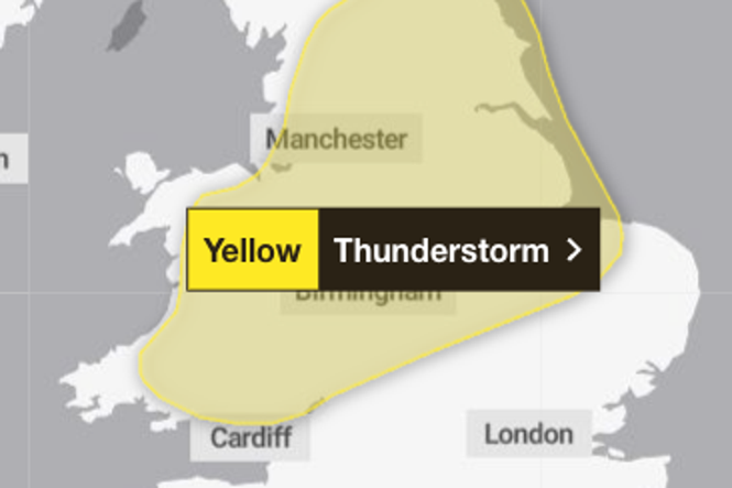
Huge swathes of the country are under a yellow weather warning for thunderstorms, as authorities warned flooding is expected in two areas.
The Met Office urged people to expect disruption to public transport and potential flooding on roads, while those in the most at-risk areas have been told to prepare an emergency kit.
It comes after significant flooding hit parts of the UK on Wednesday. Residents in Perry Barr in Birmingham were left under “three feet of water” after thunderstorms caused a local brook to burst its banks, leaving cars stranded and water up to a metre in the worst-affected homes.
The thunderstorm warning covers parts of the East Midlands, east of England, Oxfordshire, north-east England, north-west England, south-west England, Wales, the West Midlands, and Yorkshire and the Humber. The warning comes into force at midday and ends at 9pm.
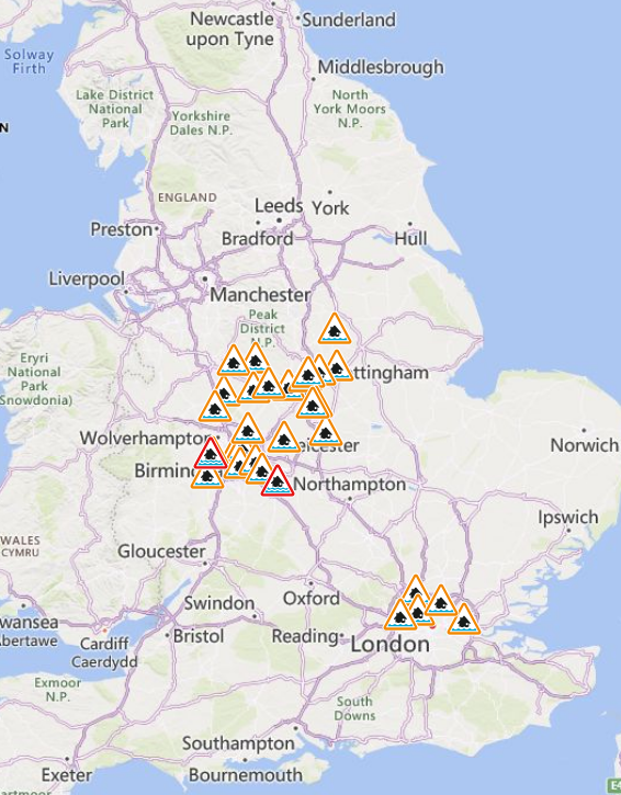
Authorities have issued flood warnings, meaning flooding is expected, and flood alerts, meaning flooding is possible, for 31 areas on Friday. The Environment Agency has issued two flood warnings and 29 flood alerts across London, the Midlands, and the north of England.
It comes after weather warnings were also issued for thunderstorms across the UK on Wednesday, dropping up to 50mm of rain across a 12-hour period in some places.
Some heavy rain is expected on Friday, particularly in the north of England and Scotland. Elsewhere, showers will become increasingly widespread, locally heavy with isolated thunder, alongside sunny spells, forecasters said.
Thundery showers and heavy rain could return over the bank holiday weekend as a band of wet weather moves eastwards, but brighter conditions are expected next week.
Met Office forecaster Craig Snell said: “To sum up the bank holiday weekend, it’s going to be pretty unsettled; there will be some sunny moments in between if you can dodge the downpours.
“It’s not going to be a complete washout. If you’ve got outdoor plans over the weekend, keep a close eye as there will be rain moving in across most parts.”
Full list of areas covered by thunderstorm warning
East Midlands
- Derby
- Derbyshire
- Leicester
- Leicestershire
- Lincolnshire
- Northamptonshire
- Nottingham
- Nottinghamshire
- Rutland
East of England
- Bedford
- Cambridgeshire
- Norfolk
- Peterborough
London & South East England
- Oxfordshire
North East England
- Darlington
- Durham
- Hartlepool
- Middlesbrough
- Redcar and Cleveland
- Stockton-on-Tees
North West England
- Blackburn with Darwen
- Cheshire East
- Cheshire West and Chester
- Cumbria
- Greater Manchester
- Halton
- Lancashire
- Merseyside
- Warrington
South West England
- Gloucestershire
Wales
- Blaenau Gwent
- Bridgend
- Caerphilly
- Carmarthenshire
- Ceredigion
- Conwy
- Denbighshire
- Flintshire
- Gwynedd
- Merthyr Tydfil
- Monmouthshire
- Neath Port Talbot
- Newport
- Powys
- Rhondda Cynon Taf
- Swansea
- Torfaen
- Wrexham
West Midlands
- Herefordshire
- Shropshire
- Staffordshire
- Stoke-on-Trent
- Telford and Wrekin
- Warwickshire
- West Midlands Conurbation
- Worcestershire
Yorkshire & Humber
- East Riding of Yorkshire
- Kingston upon Hull
- North East Lincolnshire
- North Lincolnshire
- North Yorkshire
- South Yorkshire
- West Yorkshire
- York
Flood warnings and alerts issued as more heavy rain forecast
Ukraine war latest: CIA chief ‘told Russian counterpart to make peace with Kyiv’
Will there be storms this weekend? Bank Holiday forecast after UK doused by rain
‘We stock up on dry goods’: Readers on preparing for food shortages
Residents in tears as homes to be demolished following subsidence
Brexit and ‘Boris-wave’ spark record surge in applications for British citizenship