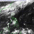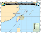
MANILA, Philippines — The national weather bureau said on Wednesday that it is closely monitoring the movement of a low pressure area (LPA) outside the Philippine Area of Responsibility (PAR) which has a medium chance of intensifying into a tropical depression.
Estimated to be some 3, 060 kilometers east of northeastern Mindanao, the weather disturbance may enter PAR but it would not directly affect the weather conditions in the country, weather specialist Chenel Dominguez said.
Another scenario, it may curve away from PAR but there would be a possibility that this would enhance the southwest monsoon locally known as ‘habagat,’ according to the Philippine Atmospheric, Geophysical and Astronomical Services Administration (Pagasa).
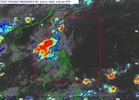
In the meantime, Pagasa said the easterlies – winds that pass through the Pacific Ocean and carry humid and warm weather – has been affecting Eastern Visayas, Dinagat Islands, Surigao del Norte, Surigao del Sur, and Davao Oriental.
While partly cloudy to cloudy skies with isolated rain showers or thunderstorms would likely occur, flash floods or landslides would also be possible in these areas especially during severe thunderstorms, she warned.
Meanwhile, Metro Manila and the rest of the country would likely experience the same weather pattern but due to the effect of the localized thunderstorms, the state-run weather agency said.