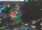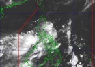
THE Philippine Atmospheric, Geophysical and Astronomical Services Administration (Pagasa) said Friday that a low pressure area near Batanes has developed into a tropical depression overnight and was named “Ester.”
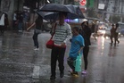
This comes after the weather bureau declared the start of the rainy season on Thursday.
In its 5 p.m. bulletin Friday, Pagasa said the center of “Ester” is 250 kilometers north of Itbayat, Batanes.
It is moving east-northeastward at 15 kph, with maximum sustained winds of up to 45 kph near the center and gustiness of up to 55 kph.
Ester, it said, will not hit the Philippine landmass but is expected to make landfall in Taiwan. It is expected to leave the Philippine Area of Responsibility (PAR) by Saturday.
“Tropical Depression Ester is forecast to move northeastward and exit the PAR on Saturday morning over the east of China Sea,” the weather bureau said.
“Although Ester may remain a tropical depression over the waters east of Taiwan, it may eventually reach tropical storm category over the East China Sea,” it added.
Batanes was under Signal No. 1 as of press time.
Meanwhile, rains were experienced in Metro Manila and other parts of the country because of the southwest monsoon.