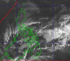
MANILA, Philippines – The low pressure area (LPA) has intensified into a tropical depression which has been forecast to enter the Philippine Area of Responsibility (PAR) on Thursday and would be named ‘Domeng,’ according to the state-run weather agency.
Nathaniel Servando, Philippine Atmospheric Geophysical and Astronomical Services Administration (Pagasa) chief, said the weather disturbance was estimated at 1, 230 kilometers east of northeastern Mindanao while moving west-northwestward at 10 kilometers per hour (kph).
“It may enter PAR on Thursday afternoon or evening and would be given the local name Domeng, the 4th storm to be hitting the country this year,” Servando said.
Forecast to reach a typhoon category on Saturday while over the Philippine Sea, it was, however, less likely to make landfall over the archipelago, according to the Pagasa administrator.
The highest wind signal that may be raised during the passage of this tropical cyclone would only be Signal No. 1, the national weather bureau said.
Meanwhile, several areas in Mindanao including Zamboanga Peninsula, Lanao del Norte, Misamis Occidental, and Palawan in Luzon would likely have cloudy skies with scattered rains and thunderstorms due to a weather system called the southwesterly wind flow.
The rest of Mindanao would be experiencing overcast skies with scattered rains and thunderstorms due to the effect of the trough of the tropical depression outside PAR, the latest Pagasa bulletin said.
On one hand, Metro Manila and the rest of the country would be experiencing partly cloudy to cloudy skies with isolated rain showers or thunderstorms due to the localized thunderstorms, it added.