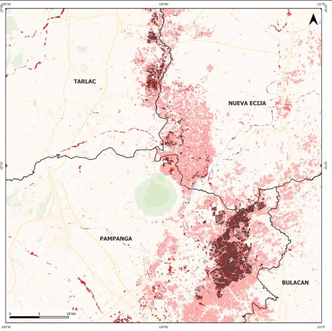
The Philippine Space Agency (PhilSA) produced flood extent maps showing inundated areas in parts of the Ilocos region, Cagayan Valley) the whole of Central Luzon and Calabarzon, Mimaropa, Cordillera Administrative Region (CAR) and the National Capital Region (NCR) on Aug. 31 at 5:45 a.m. PhST following heavy rains brought by the enhanced Southwest Monsoon (Habagat).
The maps show flood extents on Monday morning after continuous heavy rainfall late last week. The flooded zones were identified using artificial intelligence (AI) on a composite of three Sentinel-1 Synthetic Aperture Radar (SAR) satellite images. PhilSA said the data provides an operational snapshot captured during the satellite's overpass and may not reflect areas where waters have already receded.
SAR satellite imagery remains crucial for emergency assessments because radar signals penetrate thick clouds that obscure storm systems, operating day or night unlike optical sensors. However, PhilSA noted that SAR may underestimate inundation in dense urban cores and heavily vegetated areas where complex ground surfaces alter radar backscatter, leaving final maps subject to field validation.
The agency regularly supports the National Disaster Risk Reduction and Management Council (NDRRMC) and frontline agencies by supplying wide-area satellite intelligence during environmental and weather-related disasters.
In April, PhilSA conducted daily satellite tracking of the Navotas landfill fire, which ignited on April 10. The agency analyzed satellite data to monitor nitrogen dioxide plumes that drifted westward across Metro Manila and reached as far as Bataan, while using Sentinel-2 near-infrared imagery to track the fire's burn footprint across roughly 32 hectares (ha) of the facility.
PhilSA similarly mobilized satellite assets in July during the onslaught of Typhoon Inday, deploying very high-resolution imagery from international partners to verify a landslide in Calanogas, Lanao del Sur, alongside mapping widespread flood extents in Cotabato, Maguindanao del Sur, Calabarzon and Mimaropa.
PhilSA reiterated that it will continue monitoring satellite feeds as weather systems evolve, advising the public to heed advisories issued by national disaster authorities and local governments.