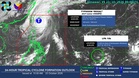
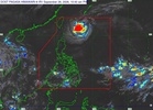
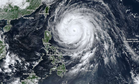
MANILA, Philippines — Typhoon "Rosal" slightly strengthened on Friday afternoon while moving northwestward away from the country’s landmass, but wind signals remained in parts of extreme Northern Luzon, according to the Philippine Atmospheric Geophysical Astronomical Services Administration (Pagasa)
In its 5 p.m. bulletin, Pagasa Weather Specialist Loriedin De la Cruz-Galicia said Rosal was 375 kilometers east of Itbayat, Batanes, moving northwestward at 20 kilometers per hour (kph).
Rosal had maximum sustained winds of 155 kph and gusts of up to 190 kph, up from 150 kph sustained winds and 185 kph gusts in a bulletin earlier in the day.
Signal No. 2 remained over Batanes, while Signal No. 1 was in effect over northern Cagayan, including the Babuyan Islands, northern Ilocos Norte and northern Apayao.
De la Cruz-Galicia said that Rosal could bring rain to parts of Northern Luzon, the Visayas and Mindanao. The typhoon was expected to exit the Philippine Area of Responsibility by Saturday morning, although wind signals could briefly remain over parts of extreme Northern Luzon.
The weather bureau advised small sea vessels in affected areas not to venture out due to rough seas. The next tropical cyclone bulletin is scheduled for 11 p.m. Friday.