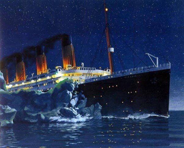
Titanic collided with an iceberg and sank
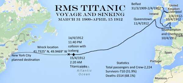
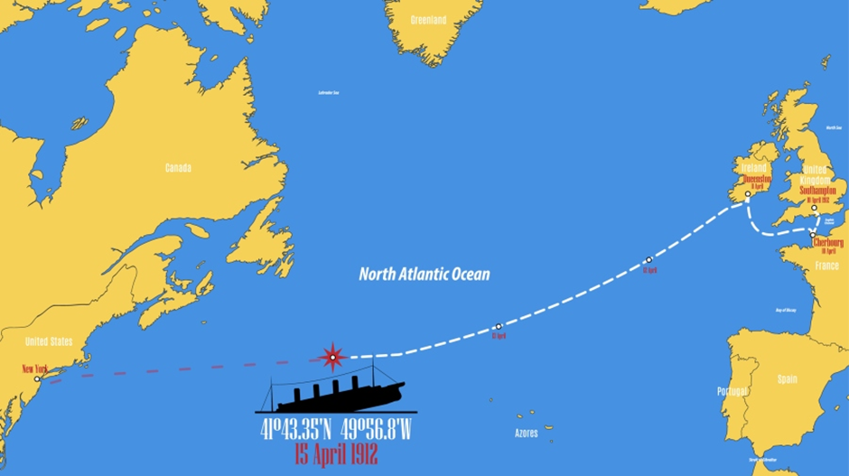
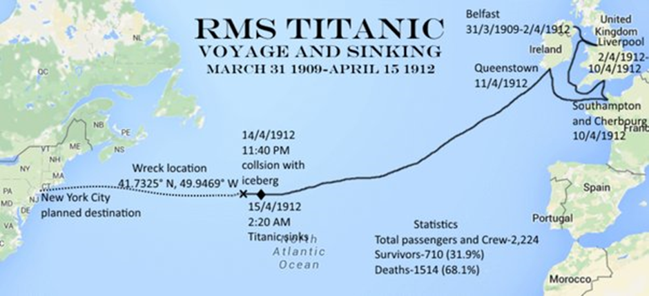
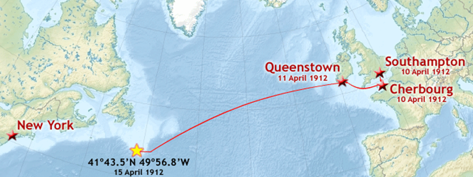
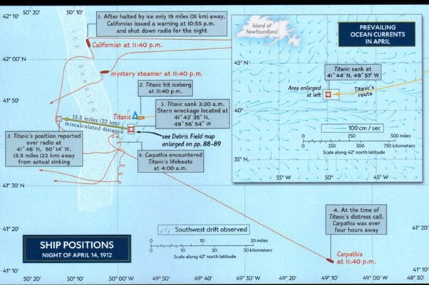
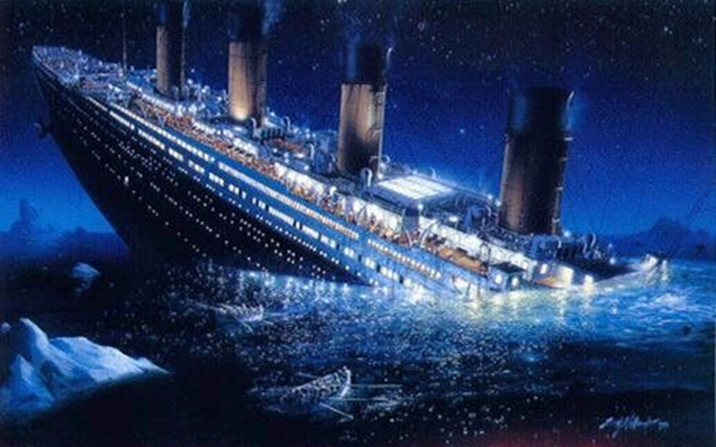
On 14th April 1912 at 11.40 pm, the Titanic hit an iceberg at Latitude 41° 46' N and Longitude 50° 14' W seriously damaging her bow (Fig 1 - Fig 3) and sank in iceberg valley. (Latitude 41° 43.5' N and Longitude 49° 56.8' W)(Fig 4) On 15th April at 2.20am, just 2 hours and 40 minutes after the collision. (Fig 1-Fig 4)
In less than three hours the pride of the White Star Line became one of the greatest marine disasters in recorded history.
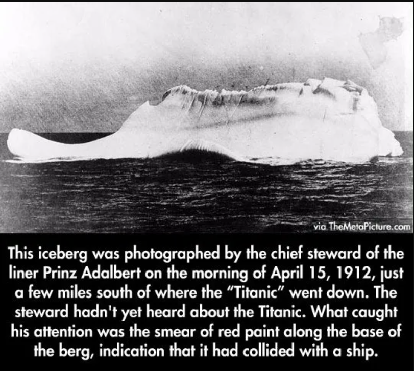
The collision occurred 1,150 miles east of New York and 450 miles south of Cape Race, the most westerly point of New Foundland. The iceberg lay at latitude 41-46N, longitude 50-14W, off the coast of Newfoundland. Newspaper reports of the time said that the visible part of the iceberg – that above the waterline – was anywhere between 50 to 100 feet high and 200 to 400 feet long. (Fig 2)
Icebergs and Iceberg Alley – Introduction
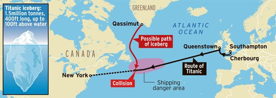
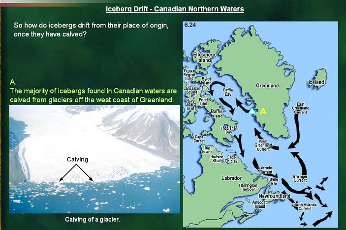
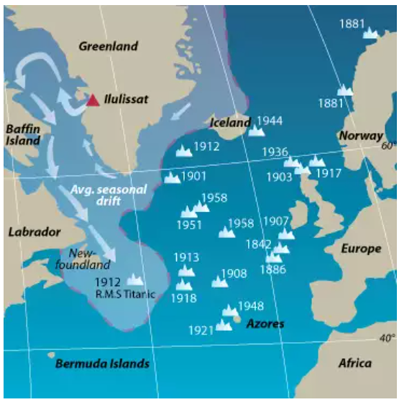
The icebergs encountered in the North Atlantic originate from the western coast of Greenland, where glaciers deliver large quantities of ice into the fjords. Every year tens of thousands of chunks of ice drop from the front of the calving glaciers into the sea. The wind then pushes the icebergs away from the coast into the West Greenland Current. This marine current transports the ice slowly north, far away from ship routes. However, following the coast of Greenland, this current is diverted along the Canadian coast to the south, forming the Labrador Current.
The map in Fig 5 shows how the currents in Baffin Bay carry the icebergs. They travel up the coast of Greenland on the West Greenland Current and down the coast of Baffin Island on the Baffin Current. They glide past Labrador and Newfoundland on the Labrador Current. They can meet passenger or cargo ships in the North Atlantic Current. (Fig 5)
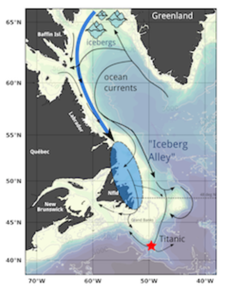
Icebergs in “Iceberg Alley” drift down from the Arctic via the Labrador current and then interact with the Gulfstream. (Fig 6)
The warm Gulf Stream melts quickly larger icebergs, breaking apart they will form swarms of smaller, yet still dangerous, chunks of ice. A more than 3,100 miles long journey full of obstacles and incessant erosion by the sun, water, and waves. After three or maybe ten years only one or two from hundreds of icebergs will reach latitude 45 degrees north, crossing the most important corridor for ships in the Atlantic Ocean.
Fig6 : Icebergs in “Iceberg Alley” drift down from the Arctic via the Labrador current and then interact with the Gulfstream
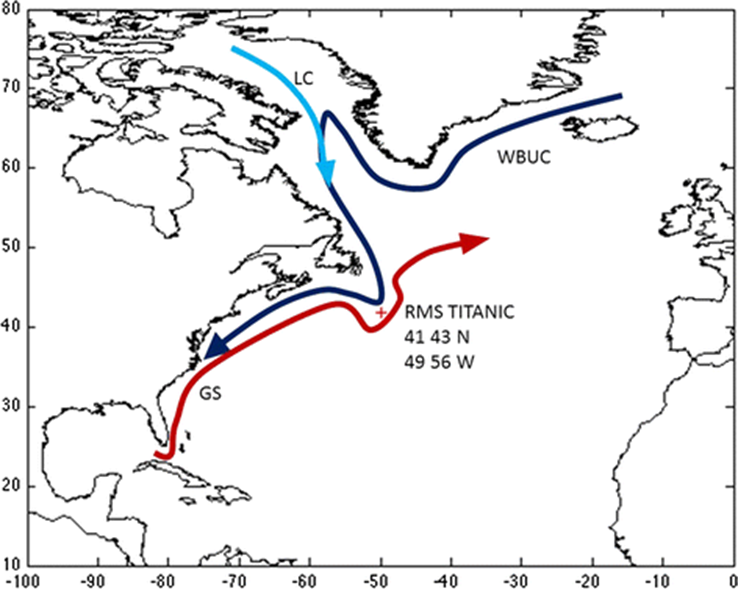
Fig 7: General depictions of the Labrador Current (LC), Western Boundary Undercurrent (WBUC) and Gulf Stream (GS) in relation to the location of the RMS Titanic
Many of the large icebergs drift as far south as the latitude 40°N before they melt. Icebergs from Kangia, and from other ice fjords and major glaciers in the west and North-west Greenland, have always been a danger to shipping on the North Atlantic routes, and it was probably one of these icebergs that sealed the fate of the Titanic in 1912. (Fig 8 and Fig 9)
Icebergs in 1912
The International Ice Patrol’s annual count of the number of icebergs that slip south of 48 degrees north provides the longest and most reliable time series of icebergs in Newfoundland. In an average year, nearly 800 icebergs are expected to cross the boundary, which lies just north of the Grand Banks of Newfoundland.
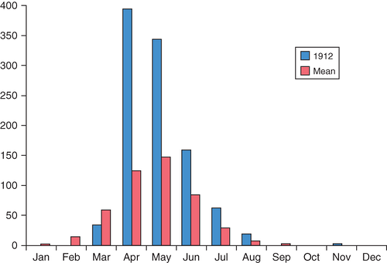
Thus during an average year, only a few hundred icebergs make it to the south of 48°N before melting away. In 1912, 1038 icebergs crossed this Latitude line with 400 of them in April (Fig 10 and Fig 11)
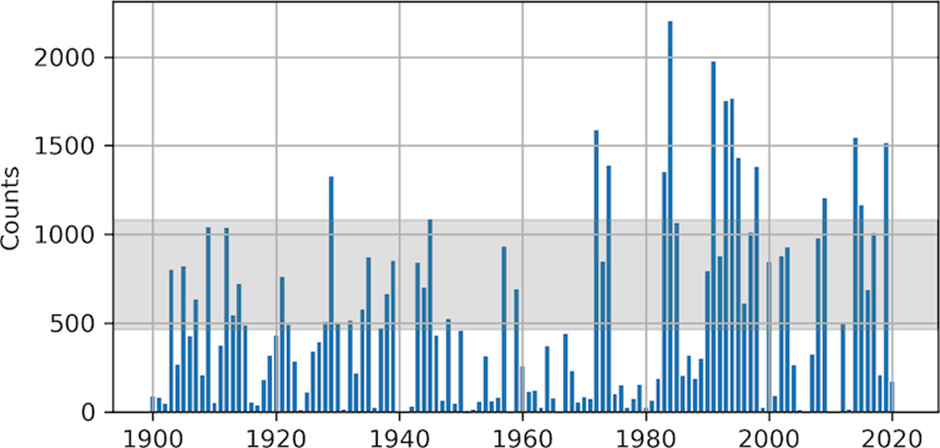
In 1912, the peak number of icebergs for the year was recorded in April, whereas normally this occurs in May, and there were nearly two and a half times as many icebergs as in an average year.
Iceberg Warnings sent to Titanic
On April 14, 1912, just four days after leaving Southampton, England (10th April 1912) on its maiden voyage to New York, the Titanic had received a series of warnings from other ships of drifting ice in the area of the Grand Banks of Newfoundland.
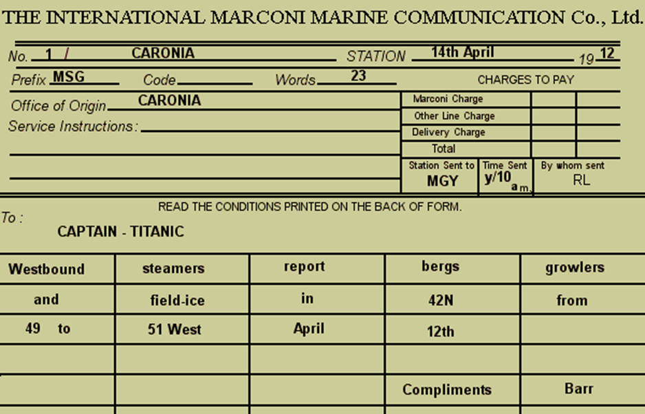
The Coronia, Noordam, Baltic, Californian and Mesaba had all sent warnings to the Titanic that there were icebergs in the area. (Fig 12 )
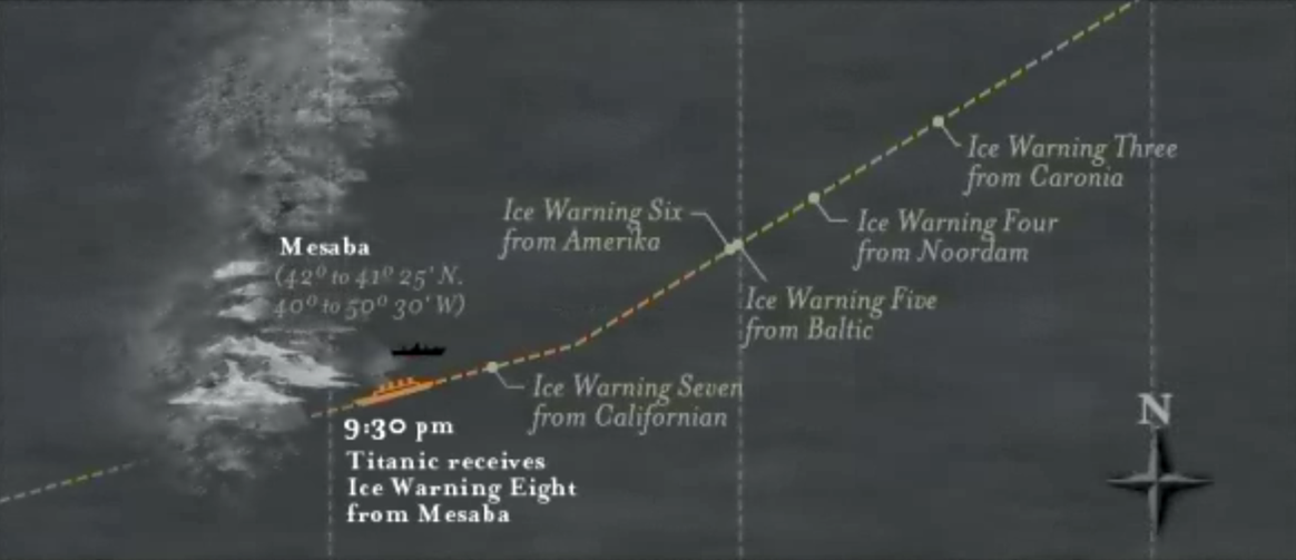
Titanics Marconi Wireless Operators Jack Philips and Bride had been receiving ice warnings starting at 9am with reports of “bergs, and growlers and field ice” from RMS Coronia at Latitude 42° N and Longitude 49-51° W. (Fig 13)
At 11:40 a.m. - A Dutch liner called the Noordman warns of much ice in the same place as the Caronia. The message is delivered to the bridge.
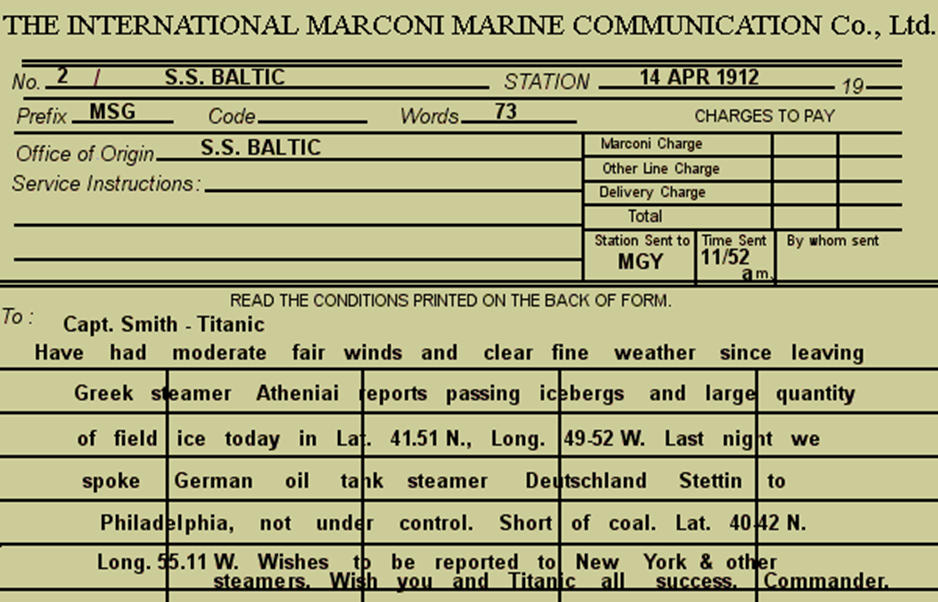
Later that day at 1.42pm, RMS Baltic warned that a Greek Ship Athenia had reported “ passing icebergs and large quantities of field ice” (Fig 14) This message is delivered to Captain Smith who gives it to Bruce Ismay (owner of the Titanic) who puts it in his pocket.
Captain Edward Smith acknowledged receipt of both these messages and shifted course a bit further south in response, but he didn’t reduce the ship’s speed.
It appeared that Titanic’s Captain Edward Smith was not overly concerned and had continued the ship’s speed at 22 knots.
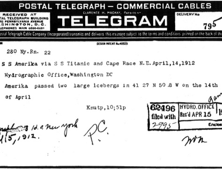
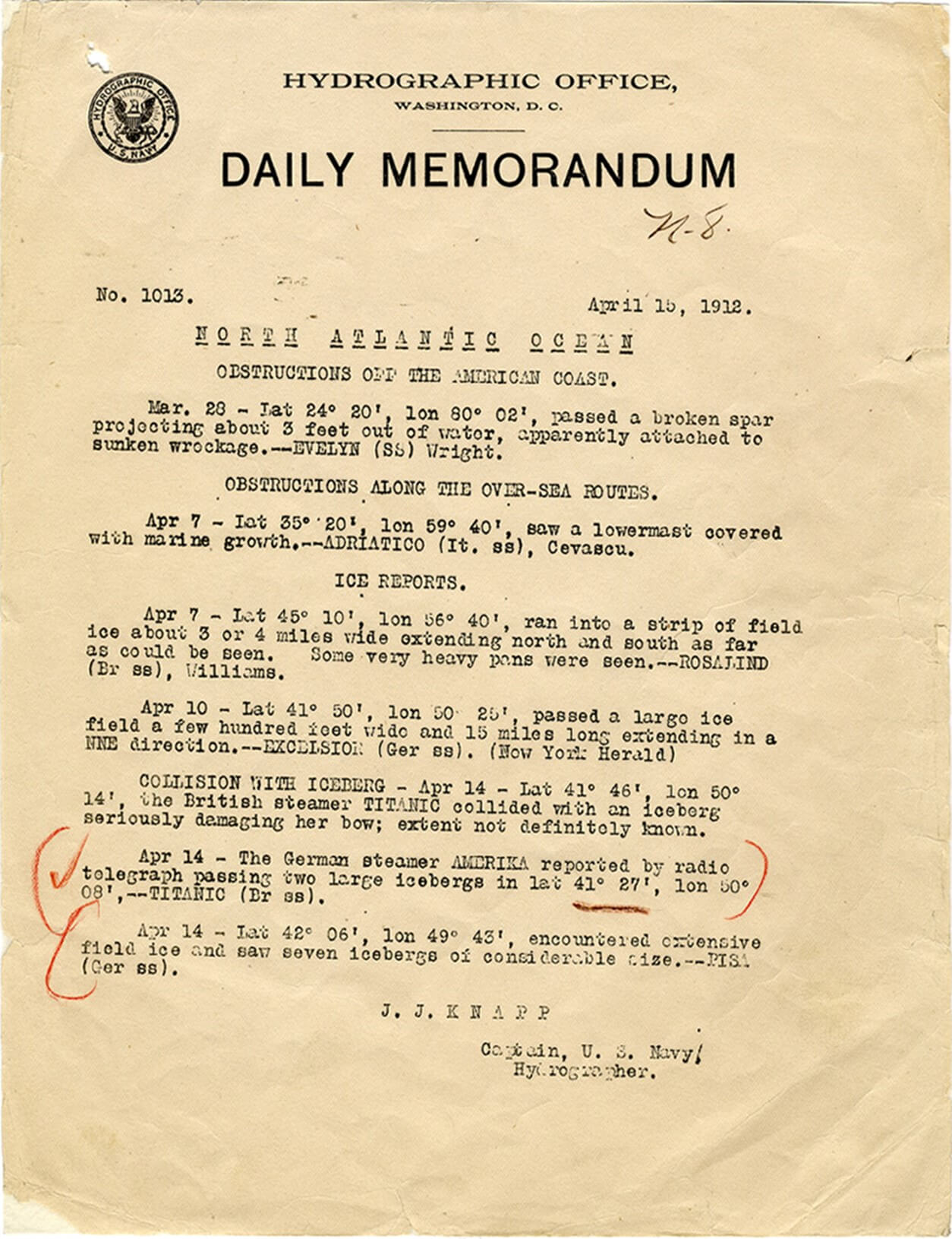
At 1.45pm, the German steamer SS Amerika, belonging to the Hamburg America Line of Germany, Eastbound, New York to Hamburg sent an ice advisory telegram message to the Hydrographic Office in Washington, DC via RMS Titanic because Titanic was nearer to Cape Race, to which station it had to be relayed to reach Washington. (Fig 15)
The SS Amerika transmitted the message “passing two large icebergs” along the Titanic’s route at Latitude 41° 27’ N and Longitude 50° 8’ W via the Titanic to the Hydrographic Office in Washington, D.C. The Titanic radio operators retransmitted the message to the Hydrographic Office but not to Titanic’s bridge.
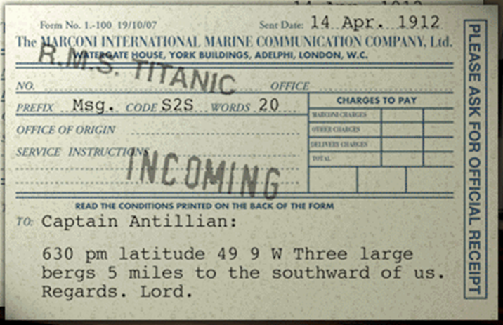
At 7.30 pm the SS California had sent messages regarding “three large bergs,” at Latitude 42° 3’ N and Longitude 49° 9’ W to the ship Antillian but these messages were overheard by the Titanic’s operators. (Fig 16)
Bride then takes the message to the bridge but Captain Smith is at a dinner party. Officer Lightoller is sailing the ship. Captain Smith never receives the message. The iceberg is now only 50 miles ahead of the Titanic.
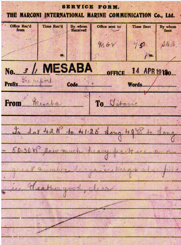
At approximately 9:40 PM the Mesaba sent a warning to Titanic about an ice field that includes “heavy pack ice and [a] great number [of] large icebergs.” At Latitude 42° N to 41° 25′, Longitude 49° W to longitude 50° 30′ W (Fig 17)
The Mesaba operator sent this message not with the prefi x MSG but with a prefi x “Ice report.” As the Mesaba operator erred in not assigning a MSG priority to the message. It never got to Captain Smith.
Because Californian was near the edge of a dangerous and considerably large ice field, the ship’s captain, Stanley Lord, had halted his ship north of the Titanic. He had decided against proceeding further into the hazardous condition in the dark and instead waited for daybreak.
Captain Stanley Lord had directed Cyril Evans, the ship’s radio operator to broadcast a warning and advice any vessels in the vicinity that they had stopped for the night (RMS Titanic in 50 Objects By Bruce Beveridge, Steve Hall, published by The History)
At 10.55pm the nearby Leyland Liner Californian sent word that it had stopped sailing after becoming surrounded by ice, to the Titanic with the message:
Titanic: MGY this is MWL. We are stopped and surrounded by ice (RMS Titanic in 50 Objects by Bruce Beveridge, Steve Hall, published by The History)
The message evidently didn’t have the proper coding to ensure it made its way to Captain Smith, though, and it didn’t include the precise lo cation of the ice field.
As the Californian's warning did not begin with the prefix MSG (Master's Service Gram), which would have required the captain to confirm he had received the message. Jack Phillips, did not to alert the ship's captain to the message as Phillips interpreted it as non-urgent and did not realize the gravity of the situation and message.
Jack Phillips response to the Californian’s final warning that night was a frustrated “Shut up! Shut up! I am working Cape Race!” (referring to a relay station at Cape Race in Newfoundland). Cyril Evans, the Californian’s radio operator then shut the ship’s system down for the night and retired.
Phillips then returned to sending passenger messages to the receiver on shore at Cape Race, Newfoundland, before it went out of range.
At 11:30 p.m. - The Californian's wireless operator, Cyril Evans turns off his set (not because he was mad but because this was normal) and goes to bed. There is now no one close enough to the Titanic with a source of communication.
Despite receiving seven ice warnings, Titanic’s Captain Smith maintained the ship’s speed of 22 knots until it hit an iceberg (Fig 1 & 2) and the ship started to sink (Fig18 - 22).
Read all parts: Part 1, Part 2, Part 3, Part 4, Part 5, Part 6, Part 7, Part 8
Sheriffah Dato Syed is a content creator under the Newswav Creator programme, where you get to express yourself, be a citizen journalist, and at the same time monetize your content & reach millions of users on Newswav. Log in to creator.newswav.com and become a Newswav Creator now!
The User Content (as defined on Newswav Terms of Use) above including the views expressed and media (pictures, videos, citations etc) were submitted & posted by the author. Newswav is solely an aggregation platform that hosts the User Content. If you have any questions about the content, copyright or other issues of the work, please contact Newswav.